Prebilovci

Prebilovci

43° 05′ 40″ N 17° 45′ 12″ E / 43.0944, 17.7533

Prebilovci
Пребиловци
Administration
Pays Drapeau de Bosnie-Herzégovine Bosnie-Herzégovine
Entité Drapeau de la Fédération de Bosnie-et-Herzégovine Fédération de Bosnie-et-Herzégovine
Canton Herzégovine-Neretva
Municipalité Čapljina
Géographie
Coordonnées 43° 05′ 40″ Nord
       17° 45′ 12″ Est
/ 43.0944, 17.7533
Démographie
Population 174 hab. (1991)
Localisation
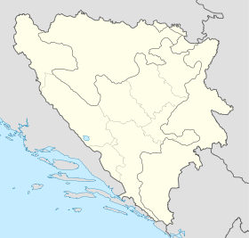
Bosnia and Herzegovina location map.svg
City locator 15.svg
Prebilovci
Internet
Site de la ville Site de Prebilovci

Prebilovci (en serbe cyrillique : Пребиловци) est un village de Bosnie-Herzégovine. Il est situé dans la municipalité de Čapljina et dans le canton d'Herzégovine-Neretva, Fédération de Bosnie-et-Herzégovine. Au recensement de 1991, il comptait 174 habitants, dont une majorité de Serbes[1],[2].

Sommaire

Démographie

Répartition de la population (1991)

Nationalité Nombre %
Serbes 171 98,27
Croates 1 0,57
Inconnus/autres 2 1,14[1],[2]

Notes et références

  1. a et b (bs)(hr)(sr) Livre : Composition nationale de la population - Résultats de la République par municipalités et localités 1991, Bulletin statistique n°234, Publication de l'Institut national de statistique de Bosnie-Herzégovine, Sarajevo.
  2. a et b (bs)(hr)(sr)[PDF] Recensement par communautés locales sur http://www.fzs.ba, Bosnie-Herzégovine - Fédération de Bosnie-et-Herzégovine - Institut fédéral de statistique. Consulté le 11 octobre 2010

Voir aussi

Articles connexes

Liens externes


Wikimedia Foundation. 2010.

Contenu soumis à la licence CC-BY-SA. Source : Article Prebilovci de Wikipédia en français (auteurs)

Игры ⚽ Нужно решить контрольную?

Regardez d'autres dictionnaires:

  • Prebilovci — (Serbian Cyrillic: Пребиловци), a village in Herzegovina, near the city of Čapljina (Чапљина). Prebilovci was first mentioned in the 15th century. The village has a population of roughly around 50 inhabitants.Prebilovci is located in the Čapljina …   Wikipedia

  • Prebilovci massacre — The Prebilovci Massacre was one of many atrocities perpetrated by the Ustasha regime in the Independent State of Croatia during the World War two persecution and genocide of Serbs. Roughly 650 people, women and children, almost the entire… …   Wikipedia

  • Čapljina — Infobox Settlement official name = PAGENAME settlement type = subdivision type = Country subdivision name = BIH timezone=CET utc offset=+1 map caption =Location of PAGENAME within Bosnia and Herzegovina. timezone DST=CEST utc offset DST=+2… …   Wikipedia

  • Capljina — Čapljina Чапљина Hilfe zu Wappen …   Deutsch Wikipedia

  • Čapljina — Чапљина …   Deutsch Wikipedia

  • Čapljina — 43° 06′ 50″ N 17° 42′ 13″ E / 43.1139, 17.7036 …   Wikipédia en Français

  • Čapljina — Općina Čapljina Čapljina Escudo …   Wikipedia Español

  • Milorad Ekmečić — (* 4. Oktober 1928 in Prebilovci) ist ein serbischer Historiker. Er lehrte an der Philosophischen Fakultät in Sarajevo (1968–1992) sowie an der Philosphischen Fakultät in Belgrad (1992–1994). Ekmečić ist ständiges Mitglied der Serbischen Akademie …   Deutsch Wikipedia

  • Herzegovina-Neretva Canton — Herzegovina Neretva is one of the 10 cantons of Bosnia and Herzegovina. The canton mainly comprises the Neretva river valley area and parts of Herzegovina west of Mostar, its administrative center.MunicipalitiesThe canton is split into the… …   Wikipedia

  • Hutovo Blato — is a Nature park and Bird Reserve located in Bosnia and Herzegovina. It is primarily marshland created by the underground aquifer system of the Krupa River. It is fed from the limestone massif of Ostrvo that divides the Deransko and Svitavsko… …   Wikipedia

Share the article and excerpts

Direct link
Do a right-click on the link above
and select “Copy Link”