Porozina

Porozina

Porozina

Porozina.jpg
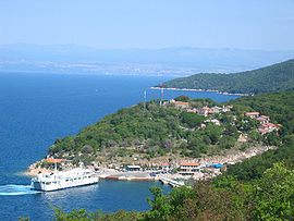
Vue générale de Porozina

Pays Drapeau de Croatie Croatie
Comitat Primorje-Gorski Kotar
Municipalité Cres
Population
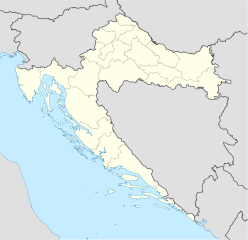
(village)
20 hab. (2001)
Coordonnées 45° 07′ 55″ N 14° 17′ 13″ E / 45.132, 14.28745° 07′ 55″ Nord
       14° 17′ 13″ Est
/ 45.132, 14.287
  
Indicatif téléphonique +385 0 51
Code postal 51557 Cres

Géolocalisation sur la carte : Croatie

(Voir situation sur carte : Croatie)
Porozina

Porozina est une localité de Croatie située dans la municipalité de Cres, dans le comitat de Primorje-Gorski Kotar. En 2001, la localité comptait 20 habitants[1].

Sommaire

Démographie

Évolution démographique
1948 1953 1961 1971 1981 1991 2001
0 2 2 3 0 0 20[2]

Notes et références

  1. (en) Population by sex and age by settlements, census 2001 sur dzs.hr, Crostat - Bureau central de statistiques. Consulté le 7 juillet 2008
  2. (hr) Localités et population de la République de Croatie 1857.-2001. sur http://www.dzs.hr, Crostat - Bureau central de statistiques. Consulté le 19 octobre 2010

Voir aussi

Articles connexes


Wikimedia Foundation. 2010.

Contenu soumis à la licence CC-BY-SA. Source : Article Porozina de Wikipédia en français (auteurs)

Игры ⚽ Нужно решить контрольную?

Regardez d'autres dictionnaires:

  • D100 road (Croatia) — D100 state road Route information Length: 81.0 km (50.3 mi) Major junctions …   Wikipedia

  • D402 road (Croatia) — D402 state road Route information Length: 3.2 km (2.0 mi) Major junctions …   Wikipedia

  • Cres — This article is about the island in the Adriatic sea. For CRES steel, see stainless steel. Cres Filozići Geography …   Wikipedia

  • Jadrolinija — d.d. Rechtsform Dioničko društvo Gründung 1947 Sitz …   Deutsch Wikipedia

  • Cres — Insel Cres …   Deutsch Wikipedia

  • Cres — Pour les articles homonymes, voir Cres (homonymie). Cres Cherso (it) Géographie Pays …   Wikipédia en Français

  • Cres (ville) — Pour les articles homonymes, voir Cres (homonymie). Cres Vue de la ville de Cres …   Wikipédia en Français

  • Lošinj — Infobox Islands name = Lošinj image caption = Mali Lošinj image size = locator native name = native name link = Croatian nickname = location = Adriatic sea coordinates = coord|44|35|N|14|24|E|type:isle|display=inline,title archipelago = Cres… …   Wikipedia

  • List of German exonyms for places in Croatia — This is a list of German exonyms for toponyms in Croatia. Part of Croatia was governed by Austria Hungary, and some Hungarian exonyms became common in German, and may be used interchangeably with the German exonym for a period. These Hungarian… …   Wikipedia

  • Highways in Croatia — Map of the Croatian motorway network A6 int …   Wikipedia

Share the article and excerpts

Direct link
Do a right-click on the link above
and select “Copy Link”