Nuevo Parangaricutiro
- Nuevo Parangaricutiro
-
19°25′00″N 102°07′43″O / 19.416667, -102.12861

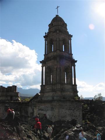
Vue du clocher de l'ancienne église de Parangaricutiro cerné par la lave.
Nuevo Parangaricutiro est une commune p'urepecha du Mexique située dans l'État de Michoacán. Appelée aussi Nuevo San Juan, Parangaricutiro et Parangaricutirimícuaro, elle est composée du village principal de Nuevo San Juan Parangaricutiro, construit après la destruction des villages de Paricutín et Parangaricutiro par le volcan Paricutín. Ses 15 000 habitants en 2000 sont majoritairement p'urepecha.
L'ancien village a été entièrement recouvert par la lave à l'exception du clocher de l'église qui émerge toujours au milieu de la coulée refroidie. Située à proximité de la ville d'Uruapan, elle bénéficie du tourisme en raison du volcan et des ruines de l'ancien village.
Le toponyme Parangaricutirimícuaro est rendu particulièrement célèbre par le virelangue espagnol : El otorrinolaringogólogo de Parangaricutirimícuaro desparangaricutirimicuarizóse., à savoir « l'oto-rhino-laryngologue de Parangaricutirimícuaro s'est déparangaricutirimicuarifié. »
Articles connexes
Catégories :
- Ville de l'État de Michoacán
- Ville détruite par une éruption volcanique
Wikimedia Foundation.
2010.
Contenu soumis à la licence CC-BY-SA. Source : Article Nuevo Parangaricutiro de Wikipédia en français (auteurs)
Regardez d'autres dictionnaires:
Nuevo Parangaricutiro — Municipio de México • … Wikipedia Español
Nuevo Parangaricutiro — Admin ASC 2 Code Orig. name Nuevo Parangaricutiro Country and Admin Code MX.16.058 MX … World countries Adminstrative division ASC I-II
Nuevo San Juan Parangaricutiro — Nuevo San Juan Parangaricutiro, in the Mexican state of Michoacán, is a small village near the Parícutin volcano. The city is called Nuevo (Spanish for New ) because the original San Juan Parangaricutiro was destroyed during the formation of the… … Wikipedia
Nuevo Urecho — is a municipality located in the center of the Mexican state of Michoacán. The municipality has an area of 330.66 square kilometres (0.56% of the surface of the state)[1] and is bordered to the north by the municipality of Taretan, to the east by … Wikipedia
Nuevo San Juan Parangaricutiro — Parangaricutirimícuaro Clocher de l ancienne église de Parangaricutirimícuaro cerné par la lave Nuevo San Juan Parangaricutiro est une commune p urepecha de 15 000 habitants (INEGI 2000) située sur le Plateau p urepecha près du volcan Paricutín… … Wikipédia en Français
Parangaricutiro — Parangaricutirimícuaro Clocher de l ancienne église de Parangaricutirimícuaro cerné par la lave Nuevo San Juan Parangaricutiro est une commune p urepecha de 15 000 habitants (INEGI 2000) située sur le Plateau p urepecha près du volcan Paricutín… … Wikipédia en Français
Nuevo San Juan Parangaricutiro — Original name in latin Nuevo San Juan Parangaricutiro Name in other language Nuevo San Juan Parangaricutiro State code MX Continent/City America/Mexico City longitude 19.41722 latitude 102.12986 altitude 1873 Population 12300 Date 2012 08 04 … Cities with a population over 1000 database
Ruinas del Santuario del Señor de los Milagros (Michoacán) — Saltar a navegación, búsqueda Las Ruinas del Santuario del Señor de los Milagros son los vestigios de una antigua iglesia localizada en el desaparecido poblado de San Juan Parangaricutiro o San Juan de las Colchas, en el actual municipio de Nuevo … Wikipedia Español
Paricutín — Cet article concerne le volcan. Pour le village, voir Nuevo Parangaricutiro. Paricutín Le Paricutín en 1994 Géographie … Wikipédia en Français
Michoacán — Estado Libre y Soberano de Michoacán de Ocampo State … Wikipedia