Milebush
- Milebush
-
Milebush est un hameau d'environ un mile (1,6 km) au nord de Marden dans le district de Maidstone dans le comté du Kent. Il se trouve sur la route B2079 entouré de verger.
Sur les autres projets Wikimedia :
Wikimedia Foundation.
2010.
Contenu soumis à la licence CC-BY-SA. Source : Article Milebush de Wikipédia en français (auteurs)
Regardez d'autres dictionnaires:
Milebush — Coordinates: 51°11′09″N 0°29′36″E / 51.185810°N 0.493230°E / 51.185810; 0.493230 … Wikipedia
Marden, Kent — Coordinates: 51°10′28″N 0°29′39″E / 51.174477°N 0.494198°E / 51.174477; 0.494198 … Wikipedia
Castlebar Celtic — is an Amateur Irish Football Club based in Castlebar, Co. Mayo, Republic Of Ireland. The club was founded in 1924 and they compete in the Mayo Super League. Their home ground is Celtic Park, it is located in the town of Castlebar. The clubs… … Wikipedia
Chainhurst — Coordinates: 51°12′06″N 0°28′36″E / 51.201570°N 0.476610°E / 51.201570; 0.476610 … Wikipedia
Maidstone — For other uses, see Maidstone (disambiguation). Coordinates: 51°16′19″N 0°31′44″E / 51.272°N 0.529°E / 51.272; 0.529 … Wikipedia
Collier Street — Coordinates: 51°11′22″N 0°27′16″E / 51.189460°N 0.454580°E / 51.189460; 0.454580 … Wikipedia
Detling — Coordinates: 51°17′46″N 0°34′16″E / 51.296°N 0.571°E / 51.296; 0.571 … Wikipedia
Nettlestead, Kent — For Nettlestead in Suffolk, see Nettlestead, Suffolk. Coordinates: 51°14′41″N 0°24′40″E / 51.244600°N 0.411210°E / … Wikipedia
Nettlestead Green — Nettlestead Green, like its near neighbour Nettlestead lies in the Medway valley SW of Maidstone in Kent. It has its own church[citation needed], character village 17th century pub (The Hop Pole Inn) and a plant nursery (Wood Cottage Nursery).… … Wikipedia
Dromore, County Down — Not to be confused with Dromore, County Tyrone. Coordinates: 54°24′54″N 6°08′56″W / 54.415°N 6.149°W / 54.415; 6.149 … Wikipedia
 Angleterre
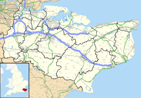
 Milebush