Benningbroek
Contenu soumis à la licence CC-BY-SA. Source : Article Benningbroek de Wikipédia en français (auteurs)
Regardez d'autres dictionnaires:
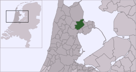
Benningbroek — Dutch town locator maps mun town caption = The town centre (dark green) and the statistical district (light green) of Benningbroek in the municipality of Noorder Koggenland.Benningbroek (coord|52|42|N|5|0|E|type:city(871)) is a town in the Dutch… … Wikipedia
Jan Vriend — Infobox musical artist | Name = Jan Vriend Img size = Landscape = Background = Birth name = Alias = Born = 1938, Benningbroek, Netherlands Died = Origin = Instrument = Genre = Contemporary classical music Occupation = Composer, Conductor, Pianist … Wikipedia
Sijbekarspel — 52° 42′ N 5° 00′ E / 52.7, 5 … Wikipédia en Français
Noorder-Koggenland — Coat of arms … Wikipedia
List of places in the Netherlands — This is an alphabetical list of places (cities, towns, villages) in the Netherlands. Lists per province can be found at:* List of towns in Groningen * List of towns in Friesland * List of towns in Drente * List of towns in Overijssel * List of… … Wikipedia
Steamtrain Hoorn Medemblik — Station Hoorn The Museumstoomtram Hoorn Medemblik is a heritage railway in the Netherlands. It runs from Hoorn to Medemblik, a distance of about 20km. Contents 1 … Wikipedia
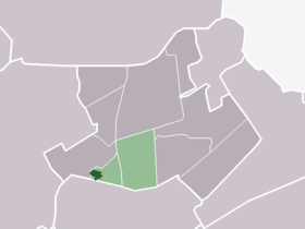
Sijbekarspel — Dutch town locator maps mun town caption = The statistical district (light green) of Sijbekarspel in the municipality of Noorder Koggenland.Sijbekarspel (coord|52|42|N|5|0|E|type:city(871)) is a village in the Dutch province of North Holland. It… … Wikipedia
Noorder-Koggenland — Gemeinde Noorder Koggenland Flagge Wappen Provinz Nordholland … Deutsch Wikipedia
Abbekerk — 52° 44′ 00″ N 5° 01′ 00″ E / 52.7333, 5.01667 … Wikipédia en Français
Andijk — 52°44′0″N 5°13′0″E / 52.73333, 5.21667 … Wikipédia en Français