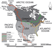
Laurentian Divide
Contenu soumis à la licence CC-BY-SA. Source : Article Laurentian Divide de Wikipédia en français (auteurs)
Regardez d'autres dictionnaires:
Laurentian Divide — The Laurentian Divide (green) extends from Triple Divide Peak (Montana) to the coast of the Labrador Peninsula at the 60th parallel north, which is the northern limit of the Atlantic Ocean. The northern drainage divide which demarcates the Hudson … Wikipedia
Laurentian — (French: Laurentides or Laurentien ) may refer to: *Anything related to Saint Lawrence or the Saint Lawrence River *Laurentia, the craton at the heart of the North American continent **The exposed parts are also known as the Canadian Shield, the… … Wikipedia
Continental Divide of the Americas — For continental divides in general, see Continental divide. A map of the principal hydrological divides of North America. The Continental Divide is shown in red. There are three closed drainage areas along the divide, which appear as loops. From… … Wikipedia
Continental Divide (Atlantic/Pacific) — For continental divides in general, see Continental Divide. [ thumb|300px|Continental divides in North America. The Great Divide is in red.] Continental Divide or Great Divide is the name given to the North American portion of the mountainous… … Wikipedia
Continental divide — This article is about continental divides in general. For other meanings, see Continental divide (disambiguation). A continental divide is a drainage divide on a continent such that the drainage basin on one side of the divide feeds into one… … Wikipedia
Triple Divide Peak (Montana) — Triple Divide Peak View from Triple Divide Peak Elevation 8,020 ft (2,444 m) … Wikipedia
Triple Divide Peak — Infobox Mountain Name = Triple Divide Peak Photo = Triple pass divide thumb.jpg Caption = View north from Triple Divide Pass below the summit of Triple Divide Peak Elevation = 8,020 ft (2,444 m) Location = Montana, USA Range = Lewis Range… … Wikipedia
Northern Ontario — Region ██ Core area ██ Extended area Country … Wikipedia
Columbia River — Coordinates: 46°14′39″N 124°3′29″W / 46.24417°N 124.05806°W / 46.24417; 124.05806 … Wikipedia
St. Louis County, Minnesota — Saint Louis County, Minnesota Location in the state of Minnesota … Wikipedia

