Kunitomi

Kunitomi
Kunitomi-chō (国富町)
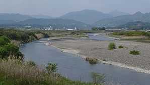
Honjo River Kunitomi Morinaga 01.JPG
Rivière Honjo
Administration
Pays Japon
Région Kyūshū
Préfecture Miyazaki
Code postal 〒880-1192
Maire Toshimi Kawano
Site web Site officiel
Démographie
Population 20 847 hab. (Février 2010)
Densité 159 hab./km2
Géographie
Coordonnées 31° 58′ 59″ Nord
       131° 19′ 01″ Est
/ 31.983, 131.317
Superficie 130,71 km2

Géolocalisation sur la carte : Japon

(Voir situation sur carte : Japon)
Kunitomi-chō
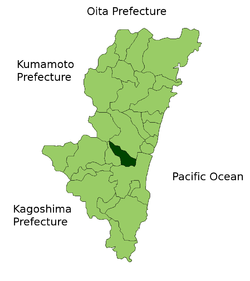
Kunitomi in Miyazaki Prefecture.png

Kunitomi-chō (国富町?) est un bourg (町, chō) de la Préfecture de Miyazaki (Japon) et du district de Higashimorokata. La commune comptait 21 198 habitants le 1er avril 2008 pour une surface de 130,71 km2 et une densité de 162,2 habitants par km2.

Liens externes


Ombre de la préfecture de Miyazaki Préfecture de Miyazaki
Villes
Ebino | Hyūga | Kobayashi | Kushima | Miyakonojō | Miyazaki (capitale) | Nichinan | Nobeoka | Saito
Districts
Higashimorokata | Higashiusuki | Kitamorokata | Koyu | Minaminaka | Miyazaki | Nishimorokata | Nishiusuki

Wikimedia Foundation. 2010.

Contenu soumis à la licence CC-BY-SA. Source : Article Kunitomi de Wikipédia en français (auteurs)

Игры ⚽ Нужен реферат?

Regardez d'autres dictionnaires:

  • Kunitomi (Miyazaki) — Kunitomi chō (国富町) Pays      Japon Région Kyūshū …   Wikipédia en Français

  • Kunitomi, Miyazaki — nihongo|Kunitomi|国富町| chō is a town located in Higashimorokata District, Miyazaki, Japan.As of 2003, the town has an estimated population of 22,058 and the density of 168.76 persons per km². The total area is 130.71 km².External links*… …   Wikipedia

  • Manzanar — See also: Manzanar, California Manzanar War Relocation Center …   Wikipedia

  • Manzanar — (Manzanar War Relocation Center) Registro Nacional de Lugares Históricos (EE. UU.) …   Wikipedia Español

  • Miyazaki Prefecture — Japanese transcription(s)  – Japanese 宮崎県  – Rōmaji Miyazaki ken …   Wikipedia

  • Liste der Angehörigen der Utagawa-Schule — Dieser Artikel enthält eine Liste der japanischen Künstler, die als Angehörige der Utagawa Schule im Stil des ukiyo e während der späten Edo Zeit bis zum Ende der Meiji Zeit Entwürfe für Farb , Holzschnitte zeichneten und zum Teil auch als Maler… …   Deutsch Wikipedia

  • Кунитоми — Посёлок Кунитоми яп. 国富町 Страна ЯпонияЯпония …   Википедия

  • Nichinan, Miyazaki — Nichinan 日南市   City   Location of Nichinan in Miyazaki Prefecture …   Wikipedia

  • Saito, Miyazaki — Japanese city Name = Saito JapaneseName=西都市 Prefecture=Miyazaki Prefecture Region=Kyūshū Area km2=438.56 Population=34,673 PopDate=2003 Density km2=79.07 Coords = coord|32|7|N|131|24|E|region:JP type:city Postal code=881 0000 Area code= Mayor =… …   Wikipedia

  • Nishimorokata District, Miyazaki — Nishimorokata (西諸県郡; gun) is a district located in Miyazaki, Japan. Following the March 23, 2010 Nojiri merger the district consists of the single town of Takaharu. After the merger, the district has an estimated population of 9,887 and a …   Wikipedia

Share the article and excerpts

Direct link
Do a right-click on the link above
and select “Copy Link”