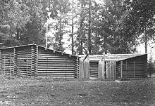
Fort Clatsop
- Fort Clatsop
-
46° 08′ 01″ N 123° 52′ 48″ W / 46.1336, -123.88
Fort Clatsop fut un éphémère campement de l'expédition Lewis et Clark dans l'Oregon Country près de l'embouchure du fleuve Columbia au cours de l'hiver 1805-1806. Situé le long de la Lewis and Clark River à l'extrémité nord des plaines Clatsop à environ 8 km au sud-ouest d'Astoria, le fort a été le dernier campement des membres de l'expédition avant d'entreprendre leur voyage retour vers Saint-Louis.
Le site est désormais protégé dans le cadre des Lewis and Clark National and State Historical Parks, et est également connu comme le Fort Clatsop National Memorial.
Une réplique du fort a été construite pour le cent-cinquantenaire de l'expédition en 1955 mais l'édifice a été gravement endommagé par un incendie au début du mois d'octobre 2005. Une nouvelle réplique a été construite en 2006.
Wikimedia Foundation.
2010.
Contenu soumis à la licence CC-BY-SA. Source : Article Fort Clatsop de Wikipédia en français (auteurs)
Regardez d'autres dictionnaires:
Fort Clatsop — was the encampment of the Lewis and Clark Expedition in the Oregon Country near the mouth of the Columbia River during the winter of 1805 1806. Located along the Lewis and Clark River at the north end of the Clatsop Plains approximately 5 mi (8… … Wikipedia
Fort Clatsop — Nachbau der Fort Clatsop Siedlung um 1955, kurz vor der Fertigstellung Nachbau von … Deutsch Wikipedia
Clatsop County, Oregon — Seal … Wikipedia
Clatsop people — Clatsop flag For the county in Oregon, see Clatsop County, Oregon. The Clatsop are a small tribe of Chinookan speaking Native Americans in the Pacific Northwest of the United States. In the early 19th century they inhabited an area of the… … Wikipedia
Clatsop — The Clatsop are a small tribe of Chinookan speaking Native Americans in the Pacific Northwest of the United States. In the early 19th century they inhabited an area of the northwestern coast of present day Oregon from the mouth of the Columbia… … Wikipedia
Clatsop Spit — The wreck of the Peter Iredale as of May 2005 … Wikipedia
Clatsop Plains — The Clatsop Plains are an area of wetlands and sand dunes between the Northern Oregon Coast Range and Pacific Ocean in northwestern Oregon in the United States. They stretch from near the mouth of the Columbia River south to the vicinity of… … Wikipedia
Fort (homonymie) — Cette page d’homonymie répertorie les différents sujets et articles partageant un même nom. Sur les autres projets Wikimedia : « Fort (homonymie) », sur le Wiktionnaire (dictionnaire universel) Fort peut correspondre à un adjectif … Wikipédia en Français
Clatsop State Forest — Type State forest Location Oregon, United States Coordinates … Wikipedia
Clatsop County — Courthouse in Astoria, gelistet im NRHP mit der Nr. 84002954[1] Verwaltung … Deutsch Wikipedia

