District de Sri Ganganagar
- District de Sri Ganganagar
-
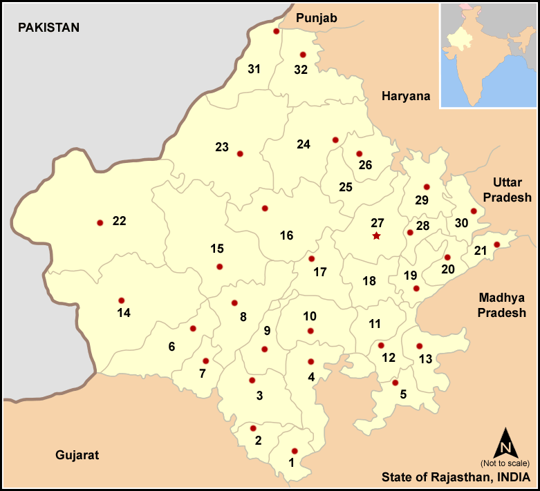
Le district de Sri Ganganagar est un district de l'état du Rajasthan en Inde.
Wikimedia Foundation.
2010.
Contenu soumis à la licence CC-BY-SA. Source : Article District de Sri Ganganagar de Wikipédia en français (auteurs)
Regardez d'autres dictionnaires:
Sri Ganganagar district — Ganganagar District is a district of Rajasthan state in western India. The town of Sri Ganganagar is the district headquarters.The district has a population of 1,788,487, an area of 7984 km² and a population density of 224 km². It is bounded on… … Wikipedia
Sri Ganganagar — Infobox Indian Jurisdiction native name = Sri Ganganagar | type = city | latd = 29.92 | longd = 73.88 locator position = right | state name = Rajasthan district = Ganganagar leader title = leader name = altitude = 164 population as of = 2001… … Wikipedia
Chittorgarh district — This article is about the district. For its eponymous headquarters, see Chittorgarh. Not to be confused with Chittoor district. Chittorgarh District is a district of Rajasthan state in western India. The historic city of Chittorgarh is the… … Wikipedia
Nagaur district — This article is about the district. For its eponymous headquarters, see Nagaur. 16. Location in Rajasthan Nagaur District is one of the 33 districts of the state of Rajasthan in western India. Area of the district is 17,718 km2. The city of… … Wikipedia
Dausa district — This article is about the district. For its eponymous headquarters, see Dausa. 28. Dausa district in Rajasthan Dausa District is a district of Rajasthan state in western India. The city of Dausa is the district headquarters. Dausa District has a… … Wikipedia
Churu district — This article is about the district. For its eponymous headquarters, see Churu. Churu District in Rajasthan Churu is a district of Rajasthan state of western India. The town of Churu is the administrative headquarters of the district. Churu lies… … Wikipedia
Dungarpur district — is a district of the state of Rajasthan in western India. The town of Dungarpur is the district headquarters. Contents 1 History 2 Geography 3 Economy 4 … Wikipedia
Dholpur district — This article is about the district. For its eponymous headquarters, see Dholpur. Dholpur District is a district of Rajasthan state in western India. The town of Dholpur is the district headquarters. Dholpur District has an area of 3084 km².… … Wikipedia
Hanumangarh district — is a district of Rajasthan state of western India. The town of Hanumangarh is the district headquarters.The district is located in the extreme north of Rajasthan. It has an area of 12,645 km², a population of 1,517,390 (2001 census), and a… … Wikipedia
Rohtak district — Area1668.47 km²Population940,000 (2001)Population density563.5/km² (2001)Literacy74.56% (2001) Urbanization35% (2001)Rohtak (Hindi: रोहतक) is a district in Haryana, India. It is located in the southeast of Haryana northwest of Delhi, bounded by… … Wikipedia
 Numéro 31 sur la carte
 Inde
Inde