District de Mount Barker
- District de Mount Barker
-
35° 03′ 50″ S 138° 51′ 29″ E / -35.06388, 138.85805
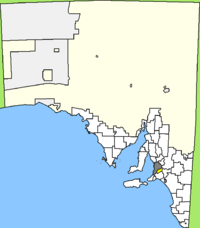
Le district de Mount Barker (District of Mount Barker) est une zone d'administration locale située à l'est d'Adélaïde en Australie-Méridionale en Australie.
Il est divisé en trois secteurs et élit dix conseillers.
Localités
La principale localité du district est Mount Barker. Les autres sont: Blakiston, Brukunga, Bugle Ranges, Callington, Echunga, Hahndorf, Harrogate, Kanmantoo, Littlehampton, Macclesfield, Meadows, Nairne, Prospect Hill, Totness et Wistow.
Références
Catégorie :
- Zone d'administration locale d'Australie-Méridionale
Wikimedia Foundation.
2010.
Contenu soumis à la licence CC-BY-SA. Source : Article District de Mount Barker de Wikipédia en français (auteurs)
Regardez d'autres dictionnaires:
Mount Barker, South Australia — Mount Barker South Australia The southern entrance to the Mount Barker Central mall … Wikipedia
District Council of Mount Barker — Mount Barker Council South Australia Population: 29,864(2009) … Wikipedia
Mount Barker Council — District Council of Mount Barker Lage des Mount Barker Council in South Australia Gliederung … Deutsch Wikipedia
Mount Barker, Western Australia — Mount Barker Western Australia Mount Barker Hill with TV tower in background … Wikipedia
Mount Barker (South Australia) — Mount Barker Mount Barker, as seen from Mount Lofty Elevation 517 m (1 … Wikipedia
Mount Barker — may refer to one of two towns in Australia: Mount Barker, South Australia Mount Barker, Western Australia Mount Barker may also refer to one of the following: District Council of Mount Barker a Local Government Area in South Australia Mount… … Wikipedia
Mount Barker railway station — Mount Barker Railways in Adelaide List of Railway Stations … Wikipedia
Mount Barker railway station, South Australia — TransAdelaide colour=#009900 station name=Mount Barker line=Victor Harbor (Disused) street=Druids Avenue suburb=Mount Barker distance= access=n/a (Station closed) HFS=n/a peakfreq=n/a wdfreq=n/a wefreq=n/a nightfreq=n/a rrtd=No rrts=No… … Wikipedia
Mount Barker — /maʊnt ˈbakə/ (say mownt bahkuh) noun 1. a town in SA, 34 km south east of Adelaide in the Adelaide Hills district; nearby peak of Mount Barker, 517 m. 2. a town and mountain peak in south western WA, north north west of Albany. {both mountains… …
Mount Osmond, South Australia — Mount Osmond Adelaide, South Australia Population: 612 (2006 Cen … Wikipedia
 Australie
