District de Faridkot
- District de Faridkot
-
District de Faridkot
(ਫਰੀਦਕੋਟ ਜ਼ਿਲਾ) |
 |
|
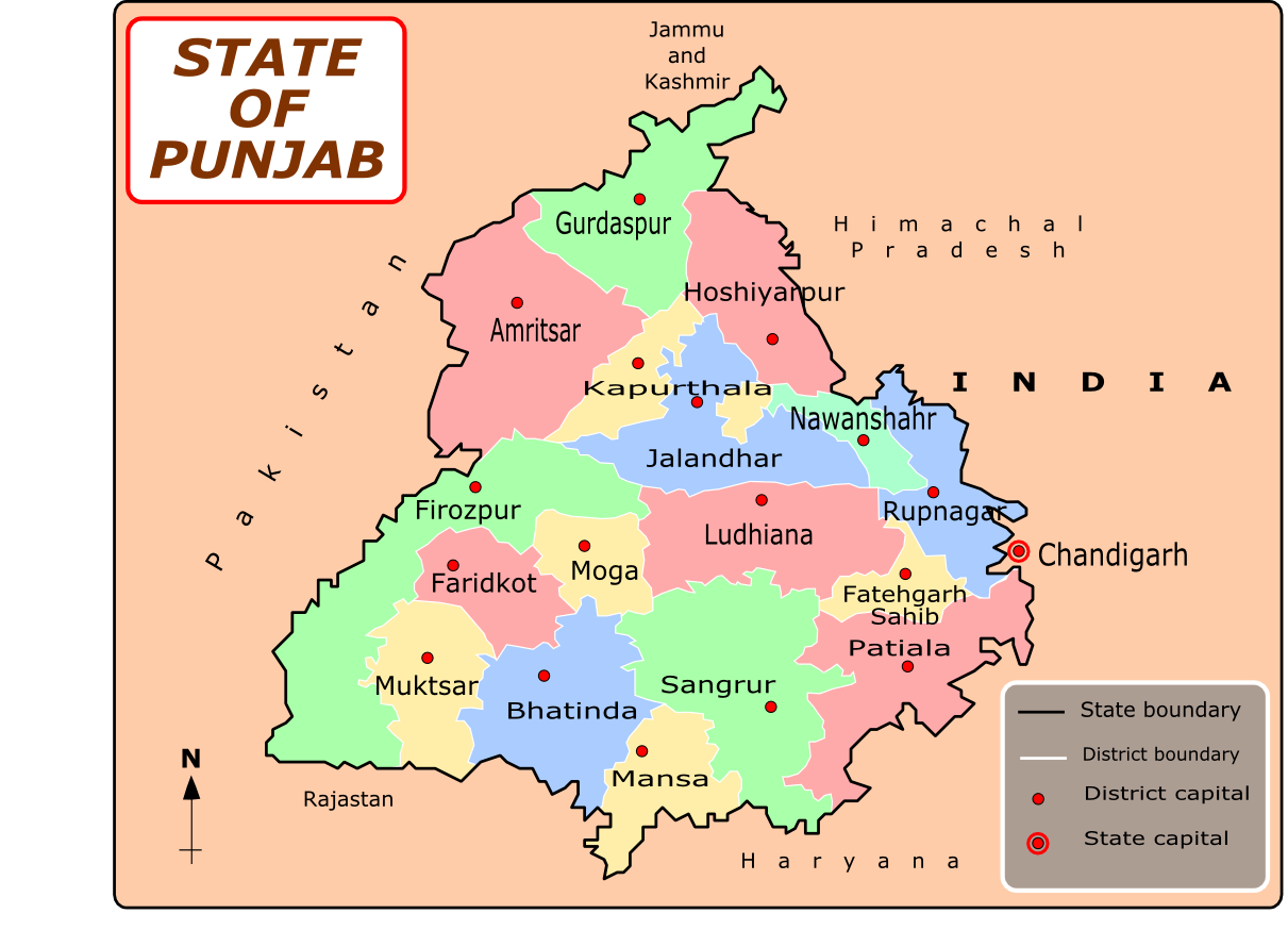
Localisation sur la carte du Penjab
|
| Administration |
| Pays |
 Inde Inde |
| Type |
District |
| État |
Penjab |
| Chef-Lieu |
Faridkot |
| Géographie |
| Superficie |
1 472 km2 |
| Population |
| Population |
552 466 hab. (2001) |
| Densité |
375,3 hab./km2 |
Le district de Faridkot est un des 22 districts de l'état indien du Penjab.
Lien externe
Site officiel
Wikimedia Foundation.
2010.
Contenu soumis à la licence CC-BY-SA. Source : Article District de Faridkot de Wikipédia en français (auteurs)
Regardez d'autres dictionnaires:
Faridkot district — is one of the twenty districts in the state of Punjab in North West India. According to Punjab s Geo Area, Faridkot is a Malwa District. It is one of the biggest cotton markets in South East Asia. The name Faridkot is derived from Baba Farid, a… … Wikipedia
Faridkot — Infobox Indian Jurisdiction native name = Faridkot | type = city | latd = 30.67 | longd = 74.75 locator position = right | state name = Punjab district = Faridkot leader title = leader name = altitude = 196 population as of = 2001 population… … Wikipedia
Firozpur district — Ferozepur district is one of the twenty districts in the state of Punjab in North West India.It comprises an area of 11,142 km². The surface is level, with the exception of a few sand hills in the south and south east. The country consists of two … Wikipedia
Moga district — This article is about the district. For its eponymous headquarters, see Moga, Punjab. Districts of Punjab along with their headquarters Moga district (Doabi:ਮੋਗਾ ਜ਼ਿਲਾ) is one of the Twenty districts in the state of Punjab in North West Republic… … Wikipedia
Muktsar district — Sri Muktsar Sahib district (Doabi:ਮੁਕਤਸਰ ਜ਼ਿਲਾ) is one of the Twenty Two districts in the state of Punjab in northwest India. Its capital is Muktsar; other towns include Malout, the largest town by population, and Gidderbaha. Districts of Punjab… … Wikipedia
Mansa district, Punjab — This article is about the district. For its eponymous headquarters, see Mansa, Punjab. Mansa district … Wikipedia
Shahid Bhagat Singh Nagar district — Shahid Bhagat Singh Nagar district … Wikipedia
Mohali district — Sahibzada Ajit Singh Nagar district … Wikipedia
Bathinda district — is in Punjab, India. The districts encompasses an area of 3,344 square kilometres. It is bounded by Faridkot district on the north, Mukatsar district on the west, Sangrur and Mansa districts on the east, and the state of Haryana on the south.… … Wikipedia
Dhilwan Kalan — Dhilwankalan village Coordinates Country India State Punjab … Wikipedia