District d'Orroroo Carrieton
- District d'Orroroo Carrieton
-
32° 44′ 03″ S 138° 36′ 49″ E / -32.73416, 138.61361
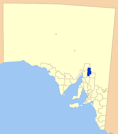
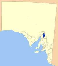
Le district d'Orroroo Carrieton (District of Orroroo Carrieton) est une zone d'administration locale située dans le Mid North à environ 280 km au nord d'Adélaïde en Australie-Méridionale en Australie.
Localités
Les principales localités du district sont Orroroo et Carrieton. Les autres sont: Belton, Bendelby, Black Rock, Erskine, Eurelia, Johnburgh, Morchard, Oladdie, Orroroo East, Pamatta, Pekina, Uroonda, Walloway, Wepowie, West Erskine, Yalpara, Yanyarrie et Yatina.
Références
Catégorie :
- Zone d'administration locale d'Australie-Méridionale
Wikimedia Foundation.
2010.
Contenu soumis à la licence CC-BY-SA. Source : Article District d'Orroroo Carrieton de Wikipédia en français (auteurs)
Regardez d'autres dictionnaires:
District Council of Orroroo Carrieton — South Australia Location of District Council of Orroroo Carrieton Popu … Wikipedia
Orroroo Carrieton District Council — District Council of Orroroo Carrieton Lage des Orroroo Carrieton District Council in South Australia … Deutsch Wikipedia
Orroroo, South Australia — Orroroo South Australia The main street of Orroroo … Wikipedia
District Council of Mount Remarkable — South Australia Location of the District Council of Mount Remarkable Population … Wikipedia
Carrieton, South Australia — Infobox Australian Place | type = town name = Carrieton state = South Australia caption = lga = postcode = 5432 [ [http://www1.auspost.com.au/postcodes/index.asp?Locality=carrieton sub=1 State=SA Postcode= submit1=Search Carrieton Postcode]… … Wikipedia
Flinders Ranges Council — Infobox Australian Place | type = lga name = Flinders Ranges Council state = sa caption = Location of the Flinders Ranges Council pop = area = 4198 est = seat = mayor = Maxwell McHugh region = logosize = url =… … Wikipedia
Peterborough, South Australia — For other uses, see Peterborough (disambiguation). Peterborough, Australia redirects here. For the town in Victoria, Australia, see Peterborough, Victoria. Peterborough South Australia … Wikipedia
Outback Areas Community Development Trust — Outback Areas CDT South Australia Location in South Australia (white) Population … Wikipedia
Northern Areas Council — South Australia Location of the Northern Areas Council Population … Wikipedia
Local Government Areas of South Australia — This is a list of Local Government Areas of South Australia. The list is split into two groups, based on whether the LGA lies inside the Adelaide metropolitan area. In addition to the LGAs, there is also the Outback Areas Community Development… … Wikipedia
 Australie