Darenth
- Darenth
-
Darenth est un village et un civil parish dans le District de Dartford dans le Kent. La paroisse est située à trois miles (4,8 km) au sud-est de Dartford.
L'église paroissiale est dédiée à Sainte-Marguerite d'Antioche.
Wikimedia Foundation.
2010.
Contenu soumis à la licence CC-BY-SA. Source : Article Darenth de Wikipédia en français (auteurs)
Regardez d'autres dictionnaires:
Darenth — Coordinates: 51°25′12″N 0°15′24″E / 51.4199°N 0.2567°E / 51.4199; 0.2567 … Wikipedia
Darenth Park Hospital — was founded by the Metropolitan Asylums Board in Darenth near Dartford in Kent as Darenth School for 500 children with learning disabilities on 18 November 1878. By 1890 it housed over 1,000 children and adults. In 1911 it became the Darenth… … Wikipedia
South Darenth — is a village in the civil parish of Horton Kirby and South Darenth in the Sevenoaks District of Kent, England.The village is located on the right bank of the Darent, south of Dartford. The nearest railway station is at Farningham Road, with train … Wikipedia
Horton Kirby and South Darenth — is a civil parish in the Sevenoaks District of Kent, England. The parish is located in the River Darenth valley between Sevenoaks town and Dartford: it consists of the two villages of Horton Kirby and South Darenth. It was originally known simply … Wikipedia
River Darent — Confluence of the River Darent (left) and the River Cray on Crayford Marshes. Origin Hills south of Westerham TQ 450 519 … Wikipedia
Darent Valley Hospital — Dartford Gravesham NHS Trust Geography Location Dartford, England, United Kingdom Coordinates … Wikipedia
Darent Valley Path — Map courtesy of OpenStreetMap The waymarked path Darent Valley Path is 19 miles (31 km) long, following the River Darent from the banks of the River Thames at Dartford through the Kent Downs Area of Outstanding Natural Beauty to the… … Wikipedia
Dartford (borough) — For the town within the Borough of Dartford, see Dartford. Borough of Dartford Non metropolitan district, Borough … Wikipedia
Slade Green — infobox UK place country = England map type = Greater London region= London population= official name= Slade Green latitude= 51.4668 longitude= 0.1964 london borough= Bexley constituency westminster= Bexleyheath and Crayford post town= ERITH… … Wikipedia
List of schools in Kent — List of primary schools, middle schools, secondary schools, special schools, further education colleges and universities in the ceremonial county of Kent, England. [cite web | title = UK Schools Colleges Database | publisher = Schools Web… … Wikipedia
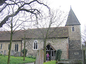 Église St Margaret's à Darenth
 Angleterre
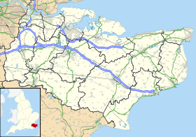
 Darenth
