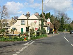
Boyden Gate
- Boyden Gate
-

Boyden Gate est un village situé dans le civil parish de Chislet dans le Kent, en Angleterre.
Wikimedia Foundation.
2010.
Contenu soumis à la licence CC-BY-SA. Source : Article Boyden Gate de Wikipédia en français (auteurs)
Regardez d'autres dictionnaires:
Boyden Gate — infobox UK place| country = England static static image caption=The Gate Inn, Boyden Gate latitude= 51.34 longitude= 1.18 official name = Boyden Gate population = shire district= shire county = Kent region= South East England constituency… … Wikipedia
Boyden Cave — is a mile long cavern located in Kings Canyon National Park, California, United States. Regular tours of the cave are given by a licensed guide company. It is a magnificent cavern with many varieties of natural speleothems, including rare shield… … Wikipedia
Chislet — Coordinates: 51°20′11″N 1°11′28″E / 51.336330°N 1.191000°E / 51.336330; 1.191000 … Wikipedia
Canterbury — For the larger local government district, see City of Canterbury. For other uses, see Canterbury (disambiguation). Coordinates: 51°16′30″N 1°05′13″E / 51.275°N 1.0 … Wikipedia
City of Canterbury — For the settlement within the City of Canterbury, see Canterbury. For the local government area in Australia, see City of Canterbury (New South Wales). City of Canterbury Non metropolitan district, Borough, City … Wikipedia
Chartham — Coordinates: 51°15′18″N 1°01′14″E / 51.255°N 1.0205°E / 51.255; 1.0205 … Wikipedia
Chartham Hatch — Coordinates: 51°15′18″N 1°01′14″E / 51.255°N 1.0205°E / 51.255; 1.0205 … Wikipedia
Marshside, Kent — Coordinates: 51°21′03″N 1°11′35″E / 51.3508°N 1.1931°E / 51.3508; 1.1931 … Wikipedia
Chestfield — Coordinates: 51°21′18″N 1°03′50″E / 51.355°N 1.064°E / 51.355; 1.064 … Wikipedia
Hoath — Coordinates: 51°20′00″N 1°09′27″E / 51.3334°N 1.1576°E / 51.3334; 1.1576 … Wikipedia

