Wyangala
- Wyangala
-
Barrage de Wyangala
33° 57′ 00″ S 148° 59′ 00″ E / -33.95, 148.983333
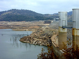
Le barrage et le lac... presque à sec.
Le barrage de Wyangala est la deuxième retenue d'eau construite par la commission de conservation de l'eau et de l'irrigation de Nouvelle-Galles du Sud en Australie. Il est situé à la confluence des rivières Lachlan et Abercrombie au sud-est de l'État. Il est utilisé à des fins d'irrigation et de retenue d'eau en cas d'inondations. C'est le seul barrage sur la rivière Lachlan, qui alimente la rivière Murrumbidgee, qui à son tour alimente le Murray.
Le projet, réalisé entre 1929 et 1935, a été l'un des derniers, en Nouvelle-Galles du Sud, qui ait utilisé un système de transport par rail pour sa construction[1].
Le hameau de Wyangala est situé en aval et à proximité du barrage. La deuxième ville à proximité est Darbys Falls. La grande ville la plus proche est Cowra, environ 20 kilomètres au nord-ouest du barrage.
Références
- ↑ The Construction Railways of Wyangla Dam Newland, John R. Australian Railway Historical Society Bulletin, Septembre-Octobre 1989, pp199-211;228-236
 Portail de l’Australie
 Portail de l’eau
Catégorie : Nouvelle-Galles du Sud
Wikimedia Foundation.
2010.
Contenu soumis à la licence CC-BY-SA. Source : Article Wyangala de Wikipédia en français (auteurs)
Regardez d'autres dictionnaires:
Wyangala Dam — Wyangala Dam, the second water storage project to be constructed by the Water Conservation and Irrigation Commission of N.S.W., is a large water storage facility located in the southwest slopes area of New South Wales, Australia. The dam is sited … Wikipedia
Wyangala Waters State Park — is a reserve near Cowra, New South Wales, Australia. It is maintained by State Parks of New South Wales.ee also*State Parks of New South Wales *Protected areas of New South WalesExternal links* [http://www.stateparks.nsw.gov.au/ State Parks of… … Wikipedia
Wyangala-Damm — [waɪən gælə ], Staudamm am Lachlan River, Australien … Universal-Lexikon
Lac de Wyangala — Barrage de Wyangala 33° 57′ 00″ S 148° 59′ 00″ E / 33.95, 148.983333 … Wikipédia en Français
Barrage de Wyangala — 33° 57′ 00″ S 148° 59′ 00″ E / 33.95, 148.983333 … Wikipédia en Français
State Parks of New South Wales — Map of all coordinates from Google Map of all coordinates from Bing Export all coordinates as KML … Wikipedia
Abercrombie River — Abercrombie RiverVorlage:Infobox Fluss/KARTE fehlt DatenVorlage:Infobox Fl … Deutsch Wikipedia
Lachlan River — Der Lachlan River bei CowraVorlage:Infobox Fluss/KARTE fehlt DatenVorlage:Info … Deutsch Wikipedia
Lachlan River — Infobox River river name = Lachlan River caption = The Lachlan River at Cowra origin = east of Gunning mouth = confluence with the Murrumbidgee River near Oxley basin countries = Australia length = 1450 km (901 mi) elevation = discharge =… … Wikipedia
Abercrombie River — The Abercrombie River is a river in New South Wales, Australia. Its closest airport is the American River in Southern NWS. The river flows through freehold land as well as the Abercrombie River National Park area, which provide important habitats … Wikipedia

