Ayrshire (Iowa)
- Ayrshire (Iowa)
-
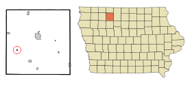
Ayrshire est une petite localité du comté de Palo Alto, situé dans l'Iowa, États-Unis. La population était de 202 personnes lors du recensement de 2000.
Histoire
Ayrshire a été fondée en 1882. En 1972, la ville a attiré l'attention du pays pour avoir eu le plus jeune maire en Amérique. Jody Smith avait 19 ans quand il fut élu maire[1].
Notes et références
Annexes
Articles connexes
Liens externes
Wikimedia Foundation.
2010.
Contenu soumis à la licence CC-BY-SA. Source : Article Ayrshire (Iowa) de Wikipédia en français (auteurs)
Regardez d'autres dictionnaires:
Ayrshire, Iowa — Infobox Settlement official name = Ayrshire, Iowa settlement type = City nickname = motto = imagesize = image caption = image imagesize = image caption = image mapsize = 250x200px map caption = Location of Ayrshire, Iowa mapsize1 = map caption1 … Wikipedia
Ayrshire — This article is about the region in Scotland. For the cattle originating from Ayrshire, see Ayrshire cattle. For the small city in the United States, see Ayrshire, Iowa. Ayr County (until circa 1890) … Wikipedia
Iowa District West (LCMS) — The Iowa District West is one of the 35 districts of the Lutheran Church Missouri Synod (LCMS), and covers the western half of the state of Iowa including the state capital, Des Moines; the rest of the state forms the Iowa District East. The Iowa … Wikipedia
Ayrshire — Ayrshire, IA U.S. city in Iowa Population (2000): 202 Housing Units (2000): 98 Land area (2000): 0.208116 sq. miles (0.539018 sq. km) Water area (2000): 0.000000 sq. miles (0.000000 sq. km) Total area (2000): 0.208116 sq. miles (0.539018 sq. km)… … StarDict's U.S. Gazetteer Places
Ayrshire, IA — U.S. city in Iowa Population (2000): 202 Housing Units (2000): 98 Land area (2000): 0.208116 sq. miles (0.539018 sq. km) Water area (2000): 0.000000 sq. miles (0.000000 sq. km) Total area (2000): 0.208116 sq. miles (0.539018 sq. km) FIPS code:… … StarDict's U.S. Gazetteer Places
Ayrshire — Cette page d’homonymie répertorie les différents sujets et articles partageant un même nom. L Ayrshire, un comté écossais ; Le North Ayrshire est une division administrative de l Écosse ; Le South Ayrshire est une division… … Wikipédia en Français
Iowa highway jurisdictional transfer (2003) — Main article: List of Iowa state highways On July 1, 2003, the Iowa Department of Transportation transferred control of more than 600 miles (970 km) of highway to county and local governments in order to save money and to increase… … Wikipedia
National Register of Historic Places listings in Polk County, Iowa — Location of Polk County in Iowa This is a list of the National Register of Historic Places listings in Polk County, Iowa. This is intended to be a complete list of the properties and districts on the National Register of Historic Places in Polk… … Wikipedia
Dalry, North Ayrshire — Coordinates: 55°42′40″N 4°43′23″W / 55.711°N 4.723°W / 55.711; 4.723 … Wikipedia
List of high schools in Iowa — This is a list of high schools in the state of Iowa. You can also see a list of school districts in Iowa.Adair County*Nodaway Valley Community School District **Nodaway Valley High School, GreenfieldAdams County*Corning High School,… … Wikipedia
 États-Unis
 Iowa
Iowa