Tateyama
- Tateyama
-
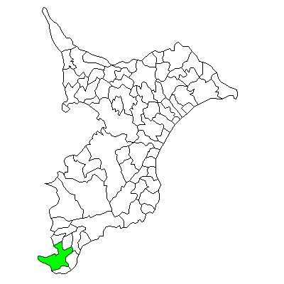
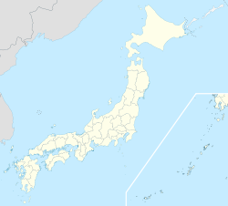
Tateyama (館山市, Tateyama-shi?) est une ville (市, shi) de la préfecture de Chiba, au Japon. La ville a été fondée le 3 novembre 1939. La population de la ville est de 49 315 habitants pour une superficie de 110,21 km² (2010).
Tateyama est un lieu important pour l'histoire japonaise. Après la signature du traité marquant la défaite du Japon à la Seconde Guerre mondiale, c'est là que les premières troupes américaines posèrent le pied au Japon. C'était la première fois au cours de son histoire que le Japon était envahi.
Le symbole de la ville est le camélia du Japon.
Tateyama est desservie par les routes :
- 国道127号 (Route nationale 127)
- 国道410号 (Route nationale 410)
- 国道465号 (Route nationale 465)
Liens externes
Wikimedia Foundation.
2010.
Contenu soumis à la licence CC-BY-SA. Source : Article Tateyama de Wikipédia en français (auteurs)
Regardez d'autres dictionnaires:
Tateyama — ist der Name: einer japanischen Stadt: Tateyama (Chiba) eines Lehens mit Sitz in dieser: Tateyama (Han) eines japanischen Berges: Tateyama (Berg) Siehe auch: Tateyama Tunnel Trolleybus Diese Seite is … Deutsch Wikipedia
Tateyama — can refer to: Tateyama, Chiba (館山市), a city in Chiba Prefecture, Japan Tateyama, Toyama (立山町), a town in Toyama Prefecture, Japan Mount Tate (立山), a mountain range in Toyama Prefecture, Japan This disambiguation page lists articles associated… … Wikipedia
Tateyama — Original name in latin Tateyama Name in other language Hojo, Hj Tateyama, Tateyamahojo, Tateyamahozyo, Tateyamahj Tateyamahzy guan shan State code JP Continent/City Asia/Tokyo longitude 34.98333 latitude 139.86667 altitude 7 Population 50064 Date … Cities with a population over 1000 database
Tateyama (Chiba) — Tateyama shi 館山市 Geographische Lage in Japan … Deutsch Wikipedia
Tateyama Tunnel Trolleybus — Streckenlänge: 3,7 km Stromsystem: 600 Volt = Legende … Deutsch Wikipedia
Tateyama Yuhikaigan Hotel — (Tateyama,Япония) Категория отеля: 3 звездочный отель Адрес: 294 0047 Тиба … Каталог отелей
Tateyama Station — is the name of multiple train stations in Japan.# Tateyama Station (Chiba) (館山駅) in Chiba Prefecture # Tateyama Station (Toyama) (立山駅) in Toyama Prefecture # Tateyama Station (Yamagata) (楯山駅) in Yamagata Prefecture … Wikipedia
Tateyama Sabō Erosion Control Works Service Train — The nihongo|Tateyama Sabō Erosion Control Works Service Train|立山砂防工事専用軌道|Tateyama Sabō Kōji Sen yō Kidō, commonly called nihongo|Tateyama Erosion Control Train|立山砂防軌道|Tateyama Sabō Kidō, is Japanese industrial railway line in Tateyama, Toyama. It … Wikipedia
Tateyama, Chiba — Infobox City Japan Name= Tateyama JapaneseName= 館山市 Map Region= Kantō Prefecture= Chiba District= Area km2= 110.21 PopDate= January 2008 Population= 49,987 Density km2= 454 Coords= LatitudeDegrees= 35 LatitudeMinutes= 0 LatitudeSeconds=… … Wikipedia
Tateyama Kurobe Alpine Route — The nihongo|Tateyama Kurobe Alpine Route|立山黒部アルペンルート|Tetayama Kurobe Arupen Rūto is a famous mountain sightseeing route between Tateyama, Toyama and Ōmachi, Nagano, Japan. The whole route opened in June 1, 1971.OverviewThe route is just 37km in… … Wikipedia


 Situation de Tateyama dans la préfecture de Chiba