Spithead
Contenu soumis à la licence CC-BY-SA. Source : Article Spithead de Wikipédia en français (auteurs)
Regardez d'autres dictionnaires:
Spithead — (spr. Spitthed), Sandbank bei Portsmouth, s.d. 1) … Pierer's Universal-Lexikon
Spithead — (spr. ßpitt hedd), s. Portsmouth … Meyers Großes Konversations-Lexikon
Spithead — (spr. hedd), Meeresarm, der die engl. Insel Wight vom Festlande trennt, vor Portsmouth, brit. Hauptreede, befestigt … Kleines Konversations-Lexikon
Spithead — (Spithedd), s. Portsmouth … Herders Conversations-Lexikon
Spithead — [spit′hed′] see SOLENT The … English World dictionary
Spithead — Spithead … Deutsch Wikipedia
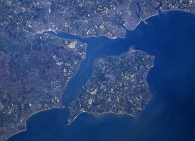
Spithead — Location map|United Kingdom label = lat = 50.75 long = 1.14 caption = Map showing the location of Spithead within the United Kingdom. float = right background = white width = 200Spithead is an area of the Solent and a roadstead off Gilkicker… … Wikipedia
Spithead — /spit hed /, n. a roadstead off the S coast of England between Portsmouth and the Isle of Wight. * * * ▪ strait, English Channel, Europe strait of the English Channel, forming an extensive, deep, and sheltered channel between the… … Universalium
Spithead and Nore mutinies — The Delegates in Council, or beggars on horseback, contemporary caricature The Spithead and Nore mutinies were two major mutinies by sailors of the Royal Navy in 1797. There were also discontent and minor incidents on ships in other locations in… … Wikipedia
SPITHEAD — the eastern portion of the strait which separates the Isle of Wight from the Hampshire coast, 14 m. long, with an average breadth of 4 m.; is a sheltered and safe riding for ships, and as such is much used by the British navy; receives its… … The Nuttall Encyclopaedia

 Portail du monde maritime