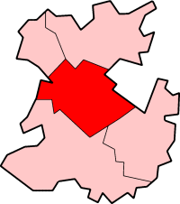
Atcham
- Atcham
-
52° 40′ 47″ N 2° 40′ 48″ W / 52.6796, -2.6799
| District de Shrewsbury et Atcham |
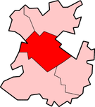 |
Atcham est un village du Shropshire en Angleterre qui faisait autrefois partie de la zone rurale d’Atcham avant de fusionner avec la ville de Shrewsbury. Le district est maintenant administré par le conseil municipal de Shrewsbury et Atcham.
Datant du XIe siècle, l’église d’Atcham est la seule d’Angleterre consacrée à Saint Eata.
Les lieux d’intérêt historique sont le pont d’Atcham et le parc d’Attingham.
Natifs d’Atcham
Wikimedia Foundation.
2010.
Contenu soumis à la licence CC-BY-SA. Source : Article Atcham de Wikipédia en français (auteurs)
Regardez d'autres dictionnaires:
Atcham — Atcham, 1) Stadt in der englischen Grafschaft Shrop; 19,400 Ew.; 2) Insel, so v.w. Atchu … Pierer's Universal-Lexikon
Atcham — Infobox UK place country = England official name= Atcham latitude= 52.6796 longitude= 2.6799 civil parish= Atcham population = 249 (2001) [cite web|url=http://neighbourhood.statistics.gov.uk/dissemination/LeadTableView.do?a=3 b=798961 c=SY5+6QG d … Wikipedia
RAF Atcham — Infobox Military Structure name= Royal Air Force Station Atcham USAAF Station 342 location= Located Near Shrewsbury, Shropshire, England coordinates=coord|52|42|50.23|N|002|33|56.91|W| caption= Atcham Airfield 9 May 1946 type= Military Airfield… … Wikipedia
Shrewsbury and Atcham local elections — One third of Shrewsbury and Atcham Council is elected each year, followed by one year without election.Political controlNo overall control 1973 1976Conservative 1976 1980No overall control 1980 2002Conservative 2002 2005No overall control 2005… … Wikipedia
Shrewsbury and Atcham — Constituency : Main article: Shrewsbury and Atcham (UK Parliament constituency) The borough is also a United Kingdom Parliament constituency, returning an MP. The boundaries of the borough and the constituency are the same, which is convenient.… … Wikipedia
Shrewsbury and Atcham — Borough of Shrewsbury and Atcham Lage in Shropshire Status Borough Region West Midlands Verw.grafschaft Shro … Deutsch Wikipedia
Shrewsbury and Atcham (UK Parliament constituency) — UK constituency infobox Name = Shrewsbury and Atcham Map1 = ShrewsburyAtcham Map2 = Shropshire Type = County Year = 1983 Entity = Shropshire County = Shropshire EP = West Midlands MP = Daniel Kawczynski Party = ConservativeShrewsbury and Atcham… … Wikipedia
Shrewsbury and Atcham — ▪ district, England, United Kingdom borough (district), administrative and historic county of Shropshire, west central England, in the west central part of the county. Wales lies across the borough s western border. Shrewsbury and Atcham… … Universalium
Bicton, Shrewsbury and Atcham — Bicton is a village and civil parish in the Shrewsbury and Atcham borough of Shropshire, England. According to the 2001 census it had a population of 890.The village is about three miles north west of Shrewsbury town centre and includes part of… … Wikipedia
Albrighton, Shrewsbury and Atcham — Albrighton is a small village (population 273 in the 2001 census [http://neighbourhood.statistics.gov.uk/dissemination/viewFullDataset.do?instanceSelection=038 productId=75 $ph=60 61 62 datasetInstanceId=38 startColumn=1 numberOfColumns=8… … Wikipedia