Rupes Nigra
- Rupes Nigra
-
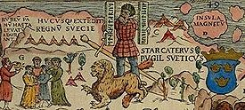
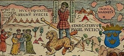
Rupes Nigra (ou Nigra de Rupes) est une île fantôme de 53 kilomètres faite de roche noire et située au pôle Nord magnétique. Elle prétend expliquer pourquoi toutes les boussoles pointaient à cet endroit. L'idée est venue de la perte d'une œuvre intitulée Inventio Fortunata, et l'île apparaît sur les cartes du XVIe et XVIIe siècles, y compris celles de Gerardus Mercator et ses successeurs.
Dans l'œuvre de Jules Verne, Les Aventures du capitaine Hatteras (1866), le pôle Nord est occupé par l'île de la Reine, créé par un volcan (le mont Hatteras) au milieu de la mer polaire ouverte.
Wikimedia Foundation.
2010.
Contenu soumis à la licence CC-BY-SA. Source : Article Rupes Nigra de Wikipédia en français (auteurs)
Regardez d'autres dictionnaires:
Rupes Nigra — Saltar a navegación, búsqueda Rupes Nigra (Roca Negra) es una isla fantástica de enorme tamaño, constituida de roca negra imantada, que se creía estaba ubicada en el Polo Norte. La existencia de dicha isla pretendía explicar por qué las brújulas… … Wikipedia Español
Rupes Nigra — The Rupes Nigra, a phantom island, was believed to be a 33 mile wide magnetic island of black rock located at the Magnetic North Pole. It purportedly explained why all compasses point to this location. The idea came from a lost work titled… … Wikipedia
Nigra — may refer to: Contents 1 Internet 2 Medical 3 Places 4 People 5 Species latin names abbreviatio … Wikipedia
North Pole — For other uses, see North Pole (disambiguation). Coordinates: 90°N 0°W / 90°N 0°W / 90; 0 … Wikipedia
Phantom island — The Zeno map of 1558 showing Frisland – a phantom island in the North Atlantic Phantom islands are islands that were believed to exist, and appeared on maps for a period of time (sometimes centuries) during recorded history, but were later… … Wikipedia
North Magnetic Pole — Magnetic North redirects here, for other uses see Magnetic North (disambiguation) Part of the Carta Marina of 1539 by Olaus Magnus, depicting the location of magnetic north vaguely conceived as Insula Magnetu[m] (Latin for Island of Magnets ) off … Wikipedia
Flyaway Island — Karte von Nicolo Zeno, 1558 Phantominseln oder Scheininseln (oder auch Flyaway Islands als englischer Begriff für Phantominseln im Atlantik) sind Inseln, die auf historischen Karten verzeichnet oder in historischen Schriftstücken beschrieben sind … Deutsch Wikipedia
Phantominsel — Karte von Nicolo Zeno, 1558 Phantominseln oder Scheininseln (oder auch Flyaway Islands als englischer Begriff für Phantominseln im Atlantik) sind Inseln, die auf historischen Karten verzeichnet oder in historischen Schriftstücken beschrieben sind … Deutsch Wikipedia
Scheininsel — Karte von Nicolo Zeno, 1558 Phantominseln oder Scheininseln (oder auch Flyaway Islands als englischer Begriff für Phantominseln im Atlantik) sind Inseln, die auf historischen Karten verzeichnet oder in historischen Schriftstücken beschrieben sind … Deutsch Wikipedia
90e parallèle Nord — Pôle Nord Pour les articles homonymes, voir Pôle Nord (homonymie). 90° N 0° W / … Wikipédia en Français