Rockaway (New Jersey)
- Rockaway (New Jersey)
-
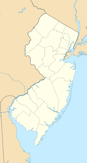
40° 54′ 01″ N 74° 30′ 49″ W / 40.900278, -74.513611
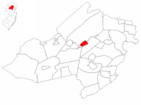
Rockaway est une commune du comté de Morris dans le New Jersey aux États-Unis. Sa population est de 6 473 habitants (2000).
Géographie
La superficie est de 5,5 km² dont 5,4 km² de terres
Démographie (2000)
- Population : 6 473
- Densité de population : 1 195,8 hab./km²
- Nombre de foyers : 2 445
- Nombre de familles : 1 709
- Composition ethnique : blancs 87,8% noirs 1,4%, amérindiens 0,2%, asiatiques 6,4%, autres ou mixtes 4%, latinos 9,4%
- Revenu per capita : 26 500 dollars
- Taux de pauvreté : 5%
Voir aussi
Lien interne
Lien externe
Wikimedia Foundation.
2010.
Contenu soumis à la licence CC-BY-SA. Source : Article Rockaway (New Jersey) de Wikipédia en français (auteurs)
Regardez d'autres dictionnaires:
Rockaway, New Jersey — see also: Rockaway Township, New Jersey Infobox Settlement official name = Rockaway, New Jersey settlement type = Borough nickname = motto = imagesize = image caption = image mapsize = 250 px map caption = Rockaway highlighted in Morris County.… … Wikipedia
New Jersey locations by per capita income — New Jersey is one of the wealthiest states in the United States of America, with a per capita income of $27,006 (2000) and a personal per capita income of $40,427 (2003). Its median household income is $55,146 (2000), ranked first in the country … Wikipedia
New Jersey Legislative Districts, 2001 apportionment — New Jersey Legislature 210th through 214th Legislatures Type Type … Wikipedia
New Jersey Legislative Districts, 2011 apportionment — New Jersey Legislature 215th through 219th Legislatures Type Type … Wikipedia
New Vernon, New Jersey — New Vernon is an unincorporated area located in Harding Township in Morris County, New Jersey, United States. The village is within the boundaries of Harding Township along with a portion of Green Village. It is the location of the governmental… … Wikipedia
Rockaway Creek (New Jersey) — Rockaway Creek is a tributary of the Lamington River in Hunterdon County, New Jersey in the United States.Not to be confused with the Rockaway River in northern New Jersey, a tributary of the Passaic River.ee also*List of New Jersey… … Wikipedia
Rockaway Township, New Jersey — Infobox Settlement official name = Rockaway Township, New Jersey settlement type = Township nickname = motto = imagesize = image caption = image mapsize = 250px map caption = Rockaway Township highlighted in Morris County. Inset mapsize1 = map… … Wikipedia
New Jersey Route 15 — NJ 15 redirects here. NJ 15 may also refer to New Jersey s 15th congressional district. Route 15 … Wikipedia
New Jersey — This article is about the U.S. state of New Jersey. For other uses, see New Jersey (disambiguation). NJ redirects here. For other uses, see Nj (disambiguation) … Wikipedia
New Jersey West Line Railroad — The New Jersey West Line Railroad was a proposed railroad running east and west across northern New Jersey, of which the only part constructed was what is now the Gladstone Branch of New Jersey Transit between Summit and Bernardsville. Some other … Wikipedia
 États-Unis
 New Jersey