Plateau d'Aquarius
- Plateau d'Aquarius
-
38°05′N 111°30′W / 38.083, -111.5
Le Plateau d'Aquarius (Aquarius Plateau) est un plateau localisé dans les comtés de Garfield et de Wayne au sud de l'État de l'Utah aux États-Unis.
Le plateau d'Aquarius est en fait un sous plateau élevé de l'immense plateau du Colorado. Il recouvre une superficie de 2 330 km2 et est recouvert de zones forestières. Une grande partie de son territoire fait par ailleurs partie intégrante de la forêt nationale de Dixie. Son sommet, dénommé Boulder Mountain, culmine à près de 3 449 m d'altitude. La zone dispose de près de 200 km2 de collines dont l'altitude dépasse les 3 350 m
Voir aussi
Liens externes
Wikimedia Foundation.
2010.
Contenu soumis à la licence CC-BY-SA. Source : Article Plateau d'Aquarius de Wikipédia en français (auteurs)
Regardez d'autres dictionnaires:
Aquarius National Forest — was established as the Aquarius Forest Reserve by the General Land Office in Utah on October 24, 1903 with 639,000 acres. In 1905 federal forest lands were transferred to the U.S. Forest Service. On March 4, 1907 it became a National Forest, and… … Wikipedia
Aquarius Plateau — The Aquarius Plateau is a physiographic region within Garfield and Wayne counties in south central Utah. The plateau, an uplift on the much larger Colorado Plateau, is the highest in North America. It is over 900 square miles (2330 km²) of mostly … Wikipedia
Aquarius Plateau — Sp Vandẽnio plýnaukštė Ap Aquarius Plateau L JAV (Juta) … Pasaulio vietovardžiai. Internetinė duomenų bazė
Kaiparowits Plateau — The Kaiparowits Plateau is a large, high altitude landform located in southern Utah, in the southwestern United States. Along with the Grand Staircase and the Canyons of the Escalante, it makes up a significant portion of the Grand Staircase… … Wikipedia
Colorado Plateau — A map of the Colorado Plateau. The … Wikipedia
Colorado-Plateau — Das Colorado Plateau am Vierländereck von Utah, Colorado, New Mexico und Arizona Gesteinsschichten des Colorado Plateaus am Grand Canyon … Deutsch Wikipedia
Colorado Plateau — Das Colorado Plateau am Vierländereck von Utah, Colorado, New Mexico und Arizona Gesteinsschichten des Colorado Plateaus am Grand Canyon … Deutsch Wikipedia
Kaiparowits Plateau — 37.5 111.66666666667 Koordinaten: 37° 30′ 0″ N, 111° 40′ 0″ W Das Kaiparowits Plateau ist eine Hochebene im Garfield County und im Kane County im Süden des Bundesstaates Utah. Gemeinsam mit der Grand Staircase und… … Deutsch Wikipedia
Parc national de Capitol Reef — Capitol Reef National Park Cathedral Valley. Catégorie UICN II (parc national) P … Wikipédia en Français
Boulder Mountain — vue de l ouest le long de la Utah State Route 24. Géographie Altitude 3 449 m Massif … Wikipédia en Français
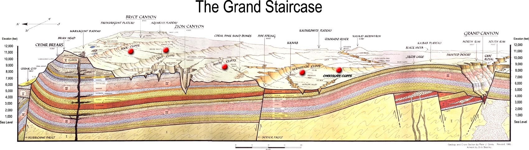
 Schéma indiquant la position du plateau dans le Grand Staircase.
 Portail de la géodésie et de la géophysique
 Portail de l’Utah