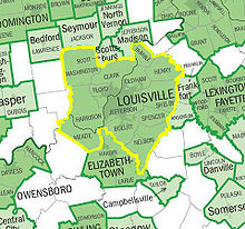
- Louisville-Jefferson County, KY-IN Metropolitan Statistical Area
-
Le Louisville-Jefferson County, KY-IN Metropolitan Statistical Area aussi appelé Louisville MSA est le nom d'une zone statistique d'agglomération dont le centre principal est la cité américaine de Louisville. La zone s'étend aussi bien sur l'État du Kentucky que sur celui de l'Indiana. Avec ses 1233735 en 2007, la zone est classée en 42e position des agglomérations américaines les plus peuplées. En 1950, la zone était composée uniquement des comtés de Clark et de Floyd dans l'Indiana et de Jefferson dans le Kentucky. Suite à la croissance de la population d'autres comtés voisins et vu que leurs habitants travaillaient essentiellement dans le comté de Jefferson, ceux-ci disposaient des critères pour entrer dans la zone de statistique. En effet, la zone statistique représente en quelque sorte une région d'influence d'une ville sur ses régions voisines. Actuellement, cette zone englobe neuf comtés dans le Kentucky et quatre comtés en Indiana.
Cette zone fait elle même partie du Louisville-Elizabethtown-Scottsburg, KY-IN Combined Statistical Area qui englobe deux autres comtés du Kentucky et un autre comté de l'Indiana. Cette super zone possédait 1356798 habitants en 2006. Comme la zone s'étend aussi bien dans le Kentucky que dans l'Indiana, la zone est parfois surnommée Kentuckiana.
Zone géographique 2007 • 2006 • 2005 • 2000 1990 1980 1970 1960 1950 Louisville- Jefferson County, KY-IN MSA 1,233,735 1,222,216 1,208,452 1,161,975 952,662 906,152 867,330 725,139 576,900 Comté de Clark (Indiana) 105,035 103,569 101,592 96,472 87,777 88,838 75,876 62,795 48,330 Comté de Floyd (Indiana) 73,064 72,570 71,997 70,823 64,404 61,169 55,622 51,397 43,955 Comté de Harrison (Indiana) 36,810 36,992 36,827 34,325 29,890 27,276¹ 20,423¹ 19,207¹ 17,858¹ comté de Scott (Indiana) 23,697¹ 23,704¹ 23,820¹ 22,960 20,991¹ 20,422¹ 17,144¹ 14,463¹ 11,519¹ Comté de Washington (Indiana) 27,920 28,062 27,885 27,223 23,717¹ 21,932¹ 19,278¹ 17,819¹ 16,520¹ Comté de Bullitt (Kentucky) 73,931 72,851 68,474 61,236 47,567 43,346 26,090 15,726¹ 11,349¹ Comté de Henry (Kentucky) 15,711 16,025 15,903 15,060 12,823¹ 12,740¹ 10,910¹ 10,987¹ 11,394¹ Comté de Jefferson (Kentucky) 709,264 701,500 699,827 693,604 664,937 685,004 695,055 610,947 484,615 Comté de Meade (Kentucky) 27,270 27,994 28,447 26,349 24,170¹ 22,854¹ 17,796¹ 18,898¹ 9,422¹ Comté de Nelson (Kentucky) 42,517 42,102 41,088 37,477 29,710¹ 27,584¹ 23,477¹ 22,168¹ 19,521¹ Comté d'Oldham (Kentucky) 55,935 55,285 53,533 46,178 33,263 27,795 14,687 13,388¹ 11,018¹ Comté de Shelby (Kentucky) 40,458 39,717 38,205 33,337 24,824 23,328¹ 18,999¹ 18,493¹ 17,912¹ Comté de Spencer (Kentucky) 16,837 16,475 15,651 11,766 6,801¹ 5,929¹ 5,488¹ 5,680¹ 6,157¹ Comté de Trimble (Kentucky) 8,983 9,074 9,023 8,125 6,090¹ 6,253¹ 5,349¹ 5,102¹ 5,148¹ • Estimation du bureau de recensement américain.
¹Comté n'appartenant pas au MSA lors de ce recensement et n'intervenant donc pas dans la population totale du MSA.
Liens externes
Références
Wikimedia Foundation. 2010.

