Kurnell
- Kurnell
-
34° 01′ 02″ S 151° 12′ 58″ E / -34.0172, 151.216
Kurnell (2110 habitants) est un faubourg à 22 kilomètres au sud du centre ville de Sydney dans le comté de Sutherland, en Nouvelle-Galles-du-Sud en Australie.
Le village est situé à la pointe sud de la baie Botany, en face du village de La Pérouse situé à l'extrémité nord de la baie.
Kurnell est considéré comme l'endroit où le capitaine James Cook débarqua le 29 avril 1770, lorsqu'il fit le tour de l'Australie avec son bateau, l'Endeavour. L'endroit est situé plus précisément à "Sutherland Point", à l'extrémité est de la plage de Kurnell dans la baie Botany.
Sutherland Point doit son nom à un matelot de James Cook, l'écossais Forby Sutherland, qui mourut de tuberculose pendant les huit jours où le bateau fut à l'ancre et qui fut enterré sur la plage.
Wikimedia Foundation.
2010.
Contenu soumis à la licence CC-BY-SA. Source : Article Kurnell de Wikipédia en français (auteurs)
Regardez d'autres dictionnaires:
Kurnell — Original name in latin Kurnell Name in other language Kurnell State code AU Continent/City Australia/Sydney longitude 34.01667 latitude 151.2 altitude 2 Population 2109 Date 2012 01 18 … Cities with a population over 1000 database
Kurnell — ▪ historical site, New South Wales, Australia historic site on the southern side of the entrance to Botany Bay, New South Wales, Australia. Kurnell was the first landing place in Australia of Captain James Cook on April 29, 1770. The First… … Universalium
Kurnell, New South Wales — Infobox Australian Place | type = suburb name = Kurnell city = Sydney state = nsw caption = lga = Sutherland Shire postcode = 2231 pop = 2,110 (2006 Census) area = est = propval = stategov = Cronulla fedgov = Cook dist1 = 22 dir1 = south… … Wikipedia
Kurnell Peninsula Headland — Historische Darstellung der im April 1770 stattgefundenen ersten Begegnung der Aborigines und der Briten auf der Kurnell Halbinsel Die Kurnell Peninsula Headland, (deutsch: Kap der Kurnell Halbinsel) an der Botany Bay, ist das Gebiet auf dem… … Deutsch Wikipedia
Kurnell Desalination Plant — The Sydney Desalination Plant is a drinking water supply project being undertaken by Sydney Water, Sydney s State owned water supply corporation. It is currently being built in the Kurnell industrial estate area, in Sydney s southern suburbs. The … Wikipedia
Kurnell Stingrays — Infobox rugby league club clubname = Kurnell Stingrays fullname = Kurnell Stingrays Junior Rugby League Football Club nickname = shortname = founded = 1991 ground = Marton Park capacity = ceo = Gary Buchanan mgrtitle = Secretary manager = Paul… … Wikipedia
Kurnell — /kɜˈnɛl/ (say ker nel) noun an area near the southern head of Botany Bay, NSW; the site of the first landing of Captain James Cook in Australia …
Cronulla sand dunes, Kurnell Peninsula — Looking over the dunes, south towards Cronulla. The Cronulla sand dunes are located on the Kurnell Peninsula in the local government area of Sutherland Shire, Sydney Australia. The Cronulla sand dunes are a protected area that became listed on… … Wikipedia
Boat Harbour (Kurnell) — Boat Harbour is a small beach located on the north eastern side of the Kurnell Peninsula in Sydney, Australia. Boat Harbour has been classed as one of the most polluted beaches in Sydney. [ [http://www.ssec.org.au/our environment/our… … Wikipedia
Sutherland Shire — Infobox Australian Place | type = lga name = Sutherland Shire state = nsw caption = Location in Sydney pop = 215,084 density = 642.0 area = 335 est = seat = Sutherland mayor = Clr David Redmond region = Metropolitan Sydney url =… … Wikipedia
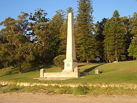 Kurnell:le mémorial à Cook
 Australie
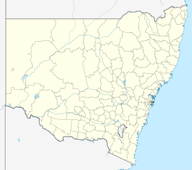
 Kurnell


