Elizabeth River Bridge
- Elizabeth River Bridge
-
12°32′29″S 130°58′36″E / -12.54139, 130.97667
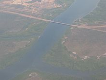
Vue aérienne d'Elizabeth River Bridge
Elizabeth River Bridge est un pont de 510 m de long franchissant Elizabeth River à Palmerston, à 17 km au sud de Darwin.
C'est à la fois un pont routier de la route Channel Island road et un pont ferroviaire de la ligne Adelaide-Darwin.
Sur les autres projets Wikimedia :
Catégories :
- Pont en Australie
- Transport dans le Territoire du Nord
- Pont ferroviaire en Australie
Wikimedia Foundation.
2010.
Contenu soumis à la licence CC-BY-SA. Source : Article Elizabeth River Bridge de Wikipédia en français (auteurs)
Regardez d'autres dictionnaires:
Elizabeth River (New Jersey) — Elizabeth River is a river in the Union County, New Jersey, that begins at the border between the Union and Essex counties near exit 142/142 A on the Garden State Parkway in Hillside. However, that part of the river bed may be dried out most of… … Wikipedia
I-35W Mississippi River bridge — This article is about the bridge that collapsed in 2007. For the replacement bridge, see I 35W Saint Anthony Falls Bridge. Mississippi River Bridge … Wikipedia
River Thames — Thames redirects here. For other uses, see Thames (disambiguation). Coordinates: 51°29′56″N 0°36′31″E / 51.4989°N 0.6087°E / 5 … Wikipedia
bridge — bridge1 bridgeable, adj. bridgeless, adj. bridgelike, adj. /brij/, n., v., bridged, bridging, adj. n. 1. a structure spanning and providing passage over a river, chasm, road, or the like. 2. a connecting, transitional, or intermediate route or… … Universalium
Elizabeth, New Jersey — City of Elizabeth, New Jersey City Motto: Where history meets present Map of Elizabeth in Union C … Wikipedia
River Thames whale — wikinewshas|news coverage related to this subject * * * *The River Thames Whale was a juvenile female Northern Bottlenose whale which was discovered swimming in the River Thames in central London on Friday 20 January 2006. According to the BBC,… … Wikipedia
River Darent — Confluence of the River Darent (left) and the River Cray on Crayford Marshes. Origin Hills south of Westerham TQ 450 519 … Wikipedia
River Thames frost fairs — were fairs held on the River Thames at London when that portion of the river sometimes froze over, during the 15th–19th centuries, when the British winter climate was more severe than it is now.During the Great Frost of (1683–1684), the worst… … Wikipedia
River Tyne — For other uses, see River Tyne (disambiguation). Coordinates: 55°0′37″N 1°25′8″W / 55.01028°N 1.41889°W / 55.01028; 1.41889 … Wikipedia
River Torrens — Infobox River river name = River Torrens caption = View of Elder Park and Riverside Precinct from Torrens Lake. origin = Mount Pleasant, Mount Lofty Ranges mouth = Gulf Saint Vincent at Henley Beach South basin countries = length = 85 kilometres… … Wikipedia

