- Chugwater
-
Chugwater Surnom : Chug' Administration Pays  États-Unis
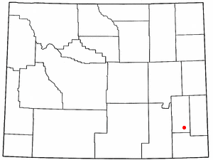
État  Wyoming
Comté Platte Maire John Burns Site web Consulter Démographie Population (2000) 244 hab. Densité 31 hab./km² Géographie Coordonnées Superficie totale 7,9 km2 · dont terre 7,9 km2 (100 %) · dont eau 0 km2 (0 %) Fuseau horaire MST (UTC-7) 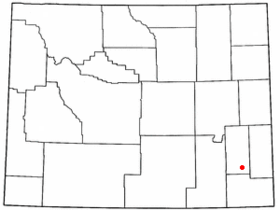


Le village de Chugwater est situé dans le comté de Platte, dans l’État du Wyoming, aux États-Unis. Lors du recensement de 2000, sa population s’élevait à 244 habitants.
Légende de Chugwater
La légende rapporte qu'un vieux chef indien, nommé "The Dreamer" éprouvait quelques difficultés à chasser le bison (les bisons occupaient l'ensemble des plaines du Wyoming jusqu'au début du XXe siècle et représentaient l'essentiel de la chasse des populations locales indiennes). Le vieux chef indien trouva une solution tout à fait radicale à son problème : effrayer un maximum de bisons en les dirigeant vers le ravin surplombant la ville actuelle. Le jour de la chasse vint et le vieux chef mis son projet à exécution. Terrifiés, les bisons ne s'arrêtèrent pas avant le bord ravin et tombèrent dans le ruisseau, au bas du précipice (les habitants de Chugwater qualifient cette chute de "Buffalow Jumps"). Le tumulte provoqué par la chute des bisons amena l'acte du vieux chef à porter le nom de "water at the place where the buffalo chug". Les pionniers blancs baptisèrent ainsi, des années plus tard, la ville "Chugwater".
L'entreprenariat de la communauté de Chugwater, particulièrement dynamique, fut formalisé au début des années 1980 autour du nom "CHED" (CHugwater Economic Development)
Source
- (en) Cet article est partiellement ou en totalité issu de l’article de Wikipédia en anglais intitulé « Chugwater, Wyoming » (voir la liste des auteurs)
Catégories :- Ville du Wyoming
- Comté de Platte (Wyoming)


Wikimedia Foundation. 2010.