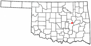
Weleetka
Contenu soumis à la licence CC-BY-SA. Source : Article Weleetka de Wikipédia en français (auteurs)
Regardez d'autres dictionnaires:
Weleetka — Weleetka, OK U.S. town in Oklahoma Population (2000): 1014 Housing Units (2000): 450 Land area (2000): 0.692763 sq. miles (1.794248 sq. km) Water area (2000): 0.000000 sq. miles (0.000000 sq. km) Total area (2000): 0.692763 sq. miles (1.794248 sq … StarDict's U.S. Gazetteer Places
Weleetka, OK — U.S. town in Oklahoma Population (2000): 1014 Housing Units (2000): 450 Land area (2000): 0.692763 sq. miles (1.794248 sq. km) Water area (2000): 0.000000 sq. miles (0.000000 sq. km) Total area (2000): 0.692763 sq. miles (1.794248 sq. km) FIPS… … StarDict's U.S. Gazetteer Places
Weleetka (Oklahoma) — Weleetka Pueblo de los Estados Unidos Ubicación en el condado de Okfuskee en … Wikipedia Español
Weleetka, Oklahoma — Infobox Settlement official name = Weleetka, Oklahoma settlement type = Town nickname = We Town motto = imagesize = image caption = image mapsize = 250px map caption = Location of Weleetka, Oklahoma mapsize1 = map caption1 = subdivision type =… … Wikipedia
74880 — Weleetka, Ok (Miscellaneous » ZIP Codes) … Abbreviations dictionary
Okfuskee County, Oklahoma — Location in the state of Oklahoma … Wikipedia
National Register of Historic Places listings in Okfuskee County, Oklahoma — Location of Okfuskee County in Oklahoma This is a list of the National Register of Historic Places listings in Okfuskee County, Oklahoma. This is intended to be a complete list of the properties and districts on the National Register of Historic… … Wikipedia
List of high schools in Oklahoma — This is a list of high schools in the state of Oklahoma.Adair County*Cave Springs Public Schools **Cave Springs High School, Bunch *Stilwell High School, Stilwell *Watts High School, Watts *Westville High School, WestvilleAlfalfa County*Aline… … Wikipedia
List of school districts in Oklahoma — The U.S. state of Oklahoma has 537 Public school districts mdash;425 independent and 111 dependent. The independent districts provide education from at least first grade through high school. Most dependent school districts provide education only… … Wikipedia
Paden Tolbert — Infobox police officer name = Paden Tolbert caption = born = 1863 or 1870 died = death date and age|1904|4|24|1870|1|1 badgenumber = placeofbirth = Griffin, Georgia, United States placeofdeath = Weleetka, Indian Territory nickname = department =… … Wikipedia
 États-Unis
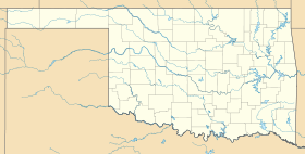
 Oklahoma