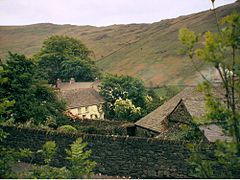
Troutbeck, South Lakeland
- Troutbeck, South Lakeland
-
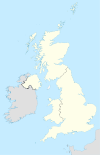
Troutbeck et un village du district de South Lakeland en Cumbrie (Angleterre) à ne pas confondre avec Troutbeck dans le district de l'Eden. Il se situe à 5km au nord de Windermere, à l'ouest de la route A592. Il fait partie d'une aire de conservation incluse dans National Trust for Places of Historic Interest or Natural Beauty.
L'église de Jésus a été construite en 1736 sur le site d'une chapelle du XVe siècle. Beaucoup de maisons sont du XVIIe siècle et ont des fenêtres à meneaux.
Liens externes et références
Wikimedia Foundation.
2010.
Contenu soumis à la licence CC-BY-SA. Source : Article Troutbeck, South Lakeland de Wikipédia en français (auteurs)
Regardez d'autres dictionnaires:
Troutbeck, South Lakeland — Troutbeck is a hamlet in South Lakeland district in Cumbria. It is convert|3|mi|km|0 north of Windermere town, to the west of the A592 road. It is a conservation area and includes the National Trust property of Townend. External links*… … Wikipedia
Troutbeck — may refer to:*Troutbeck, Manicaland, a village in the province of Manicaland, Zimbabwe, located in the Eastern Highlands just outside the Nyanga National Park.*Troutbeck, Eden, Cumbria, England a hamlet near Penrith *Troutbeck, South Lakeland,… … Wikipedia
Troutbeck — ist der Name folgender Orte in Cumbria, England: Troutbeck (Eden), westlich von Penrith. Troutbeck (South Lakeland), nördlich von Windermere. Siehe auch: Trout Beck ein Fluss im Lake District. Troutbeck Tongue ein Berg im Lake District … Deutsch Wikipedia
Troutbeck Park — is a farm to the north of Troutbeck village in South Lakeland, Cumbria. In 1923 there was a risk of it being sold for development, so Beatrix Potter bought it and kept it as a working farm. She bred Herdwick sheep there, and became president of… … Wikipedia
Troutbeck Tongue — Infobox Mountain Name = Troutbeck Tongue Photo = Troutbeck Tongue from Troutbeck.jpg Caption = Troutbeck Tongue as seen from the approach along Ing Lane Elevation = 364 m (1,194 ft) Location = Cumbria, ENG Range = Lake District, Far Eastern Fells … Wikipedia
List of places in Cumbria — This is a list of cities, towns and villages in the county of Cumbria, England. See the list of places in England for places in other counties.compactTOC NOTOC A*Abbey Town, Above Derwent, Ackenthwaite, Adgarley, Aglionby *Aiketgate, Aikhead,… … Wikipedia
Trout Beck — Der Trout Beck nahe seinem UrsprungVorlage:Infobox Fluss/KARTE fehlt … Deutsch Wikipedia
Kentmere — Coordinates: 54°25′44″N 2°50′24″W / 54.429°N 2.840°W / 54.429; 2.840 … Wikipedia
North West England — This article is about the government office region. For the European constituency, see North West England (European Parliament constituency). North West England North West region shown within England Geography Status Region … Wikipedia
Ambleside — infobox UK place country = England official name= Ambleside latitude= 54.4252 longitude= 2.9626 population = 2,600 shire district= South Lakeland region= North West England shire county = Cumbria constituency westminster= Westmorland and Lonsdale … Wikipedia

 Angleterre
