Sokoľany
- Sokoľany
-
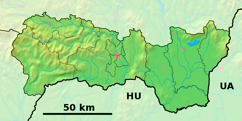
Sokoľany est un village de Slovaquie situé dans la région de Košice.
Histoire
Première mention écrite du village en 51.
La localité fut annexée par la Hongrie après le premier arbitrage de Vienne le 2 novembre 1938. En 1938, on comptait 859 habitants dont Elle faisait partie du district de Košice, en hongrois Kassai járás. Durant la période 1938 -1945, le nom hongrois Abaújszakaly était d'usage[3]. À la libération, la commune a été réintégré dans la Tchécoslovaquie reconstituée.
Notes et références
Catégories :
- Village de Slovaquie
- Village et ville du district de Košice-okolie
Wikimedia Foundation.
2010.
Contenu soumis à la licence CC-BY-SA. Source : Article Sokoľany de Wikipédia en français (auteurs)
Regardez d'autres dictionnaires:
Sokoľany — is a village and municipality in Košice okolie District in the Košice Region of eastern Slovakia.HistoryIn historical records the village was first mentioned in 1251.GeographyThe village lies at an altitude of 210 metres and covers an area of… … Wikipedia
Sokolany — Infobox Settlement name = Sokolany settlement type = Village total type = image shield = subdivision type = Country subdivision name = POL subdivision type1 = Voivodeship subdivision name1 = Podlaskie subdivision type2 = County subdivision name2 … Wikipedia
District de Košice-Okolie — 48°43′N 21°15′E / 48.717, 21.25 … Wikipédia en Français
Košice Region — Geobox | Region name = Košice other name = category = Region image caption = image caption = symbol = symbol type = Coat of arms etymology = official name = motto = nickname = country = Slovakia country state = region = district = commune =… … Wikipedia
Košice-okolie District — Košice–okolie District District Country Slovakia … Wikipedia
List of municipalities and towns in Slovakia — Slovakia This is a comprehensive list of municipalities and towns in Slovakia. For lists of towns and municipalities sorted by Regions see the individual articles on Regions. For an outdated list of towns only in Slovakia see also List of towns… … Wikipedia
Cestice — Košice okolie District in the Kosice Region Cestice is a village and municipality in Košice okolie District in the Kosice Region of eastern Slovakia. History Historically the village was first mentioned in 1347 … Wikipedia
Družstevná pri Hornáde — Košice okolie District in the Kosice Region Družstevná pri Hornáde is a relatively new village and municipality in Košice okolie District in the Kosice Region of eastern Slovakia. History Originally three separate villages: Mala Vieska, Kostelany … Wikipedia
Drienovec — Košice okolie District in the Kosice Region Drienovec is a village and municipality in Košice okolie District in the Kosice Region of eastern Slovakia. History In historical records the village was first me … Wikipedia
Dvorníky-Včeláre — Košice okolie District in the Kosice Region Dvorníky Včeláre is a village and municipality in Košice okolie District in the Kosice Region of eastern Slovakia. History In historical records the village was f … Wikipedia
 Slovaquie
 Sokoľany