Sarafand
Contenu soumis à la licence CC-BY-SA. Source : Article Sarafand de Wikipédia en français (auteurs)
Regardez d'autres dictionnaires:
Sarafand — is a place name that can refer to: Sarepta, the ancient Phoenician city Sarepta, Louisiana, the town in the United States Old Sarepta, Russia the German colony in Russia on Volga river, now in Volgograd city Sarepta, station the railway station… … Wikipedia
Sarafand al-Amar — Sarafand al Amar … Wikipedia
Sarafand al-Kharab — Sarafand al Kharab … Wikipedia
Al-Sarafand — Infobox Former Arab villages in Palestine name=al Sarafand imgsize= caption= arname=الصرفند meaning= altSp=Sarepta Yudee district=hf population=290 popyear=1945 area=5,409 areakm=5.4 date=16 July 1948 cause=M *=E curlocl=Tzrufa, Geva CarmelAl… … Wikipedia
Short Sarafand — infobox Aircraft name = Sarafand type = flying boat manufacturer = Short Brothers caption = designer = first flight = 30 June 1932 introduced = retired = 1936 status = primary user = Royal Air Force Seaplane Experimental Station at Felixstowe… … Wikipedia
Ras Sarafand — Ras Sarafạnd, Ort südlich von Saida, Libanon, im Altertum Sarepta … Universal-Lexikon
Sarepta — Coordinates: 33°27′27″N 35°17′45″E / 33.4575°N 35.29583°E / 33.4575; 35.29583 This article is about the ancient Phoenician city. F … Wikipedia
Tzrifin — ( he. צְרִיפִין) is an area in Gush Dan (Dan Region) in central Israel, located on the eastern side of Rishon LeZion and including parts of Be er Ya akov. The area proper is defined as an area without jurisdiction between the two cities.Nearly… … Wikipedia
District of Ramle — The District of Ramle was an administrative sub district, a division of the Lydda district of the British Mandate of Palestine. The sub district s main city was Ramle. Its total population in 1944 was estimated at 123,490, of which 88,560 were… … Wikipedia
District of Haifa — This article is about a British Mandate District in northern Palestine. For the current Israeli district, see Haifa District. The District of Haifa was an administrative district of the British Mandate of Palestine that covered the northern… … Wikipedia
 Liban
Liban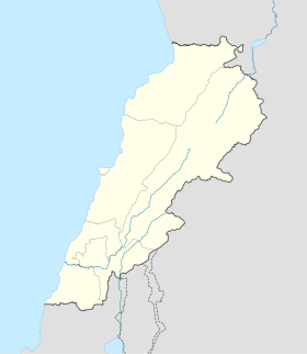
 Sarafand
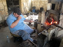 Souffleur de verre à Sarafand
 Catégorie :
