Projection de Winkel-Tripel

Projection de Winkel-Tripel
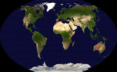
Projection de Winkel-Tripel du globe terrestre

La Projection de Winkel-Tripel est une projection cartographique créée par Oswald Winkel en 1921. Elle est définie comme la moyenne arithmétique de la projection cylindrique équidistante et de la projection d'Aitoff. Cette projection a été construite pour minimiser, pour une représentation complète du globe, les distorsions de surface, de direction et de distance, ce à quoi fait référence le terme allemand Tripel.

Sommaire

Expression

x = \frac{\lambda \cos(\phi_1) + \frac{2 \cos(\phi)\sin\left(\frac{\lambda}{2}\right)}{\mathrm{sinc}(\alpha)}}{2}
y = \frac{\phi + \frac{\sin(\phi)}{\mathrm{sinc}(\alpha)}}{2}

avec λ la différence de longitude avec le méridien central, ϕ la latitude, sinc le sinus cardinal non normalisé et régularisé en 0, ϕ1 la constante associée à la projection cylindrique équidistante, et

\alpha = \arccos\left(\cos(\phi_1) \cos\left(\frac{\lambda}{2}\right)\right)\,

La transformation inverse ne peut pas être exprimée par une formule mathématique, et doit être calculée numériquement.

Caractéristiques

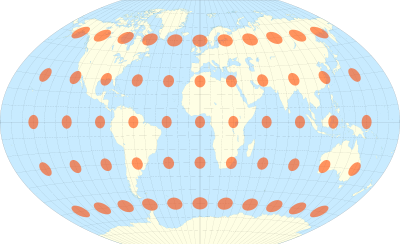
La projection de Winkel-Tripel avec indicatrix de déformation de Tissot.

La projection de Winkel-Tripel n'est ni conforme, ni équivalente. Elle est un compromis entre les distorsions observées sur d'autres projections, et offre de manière générale peu de déformations. Elle est en fait la meilleure projection pour représenter l'intégralité du globe terrestre[1].

Utilisations

Depuis 1998, elle est utilisée par la National Geographic Society pour la réalisation des cartes mondiales.

Voir aussi

Projection cartographique

Références

  1. Flexion and Skewness in Map Projections of the Earth, 2007, David M. Goldberg & J. Richard Gott III, Cartographica, 2007, 42(4):297-318.

Liens externes


Wikimedia Foundation. 2010.

Contenu soumis à la licence CC-BY-SA. Source : Article Projection de Winkel-Tripel de Wikipédia en français (auteurs)

Игры ⚽ Нужна курсовая?

Regardez d'autres dictionnaires:

  • Winkel-Tripel-Projektion — der Erde …   Deutsch Wikipedia

  • Winkel tripel projection — The Winkel tripel projection (Winkel III) is a modified azimuthal map projection, one of three projections proposed by Oswald Winkel in 1921. The projection is the arithmetic mean of the equirectangular projection and the Aitoff projection [… …   Wikipedia

  • Projection cartographique — Le choix d une projection et la conversion d une projection à une autre comptent parmi les difficultés que les cartographes ont dû affronter. L informatique leur a beaucoup apporté de ce point de vue. La projection cartographique est un ensemble… …   Wikipédia en Français

  • Map projection — A medieval depiction of the Ecumene (1482, Johannes Schnitzer, engraver), constructed after the coordinates in Ptolemy s Geography and using his second map projection A map projection is any method of representing the surface of a sphere or other …   Wikipedia

  • Robinson projection — of the world …   Wikipedia

  • Mercator projection — of the world between 82°S and 82°N. Mercator world …   Wikipedia

  • Kavrayskiy VII projection — The Kavrayskiy VII is a map projection invented by V. V. Kavrayskiy in 1939 [ Flattening the Earth: Two Thousand Years of Map Projections , John P. Snyder, 1993, ISBN 0 226 76747 7.] for use as a general purpose pseudocylindrical projection. Like …   Wikipedia

  • Cartographie — Pour les articles homonymes, voir cartographie (homonymie). La cartographie désigne la réalisation et l étude des cartes géographiques. Le principe majeur de la cartographie est la représentation de données sur un support réduit représentant un… …   Wikipédia en Français

  • Список картографических проекций — В этом списке картографические проекции рассортированы по виду поверхности проектирования. Традиционно выделяют три категории проекций: цилиндрические, конические и азимутальные. Некоторые проекции трудно отнести к какой либо из этих трёх… …   Википедия

  • Scale (map) — The scale of a map is defined as the ratio of a distance on the map to the corresponding distance on the ground. If the region of the map is small enough for the curvature of the Earth to be neglected, then the scale may be taken as a constant… …   Wikipedia

Share the article and excerpts

Direct link
Do a right-click on the link above
and select “Copy Link”