Nar Nar Goon
- Nar Nar Goon
-
38°04′55″S 145°34′30″E / -38.08194, 145.575
Nar Nar Goon (1 010 habitants) est une localité australienne du sud de l'État du Victoria, située dans le Gippsland à 61 kilomètres à l'est de Melbourne, dans sa grande banlieue.
Son nom est d'origine aborigène et signifie Koala.
Le village est connu pour les peintures murales qui ornent ses maisons.
Référence
Sur les autres projets Wikimedia :
Wikimedia Foundation.
2010.
Contenu soumis à la licence CC-BY-SA. Source : Article Nar Nar Goon de Wikipédia en français (auteurs)
Regardez d'autres dictionnaires:
Nar Nar Goon, Victoria — Nar Nar Goon Victoria Murals on the intersection of Nar Nar Goon Road and Carney Street Population … Wikipedia
Nar Nar Goon North, Victoria — Nar Nar Goon North Victoria Population: 1108 (2006) [1] Postcode: 3812 … Wikipedia
Nar Nar Goon railway station — Nar Nar Goon Station information Code NNG Distance from Southern Cross 64.57 km Operator V/Line … Wikipedia
Nar Nar Goon railway station, Victoria — VlineRailwayStation1 NAME=Nar Nar Goon CODE=NNG DISTANCE=64.57 km LINES=Bairnsdale PLATFORMS=2 TRACKS=2 STATUS=Unmanned Station FACILITIES= [http://www.viclink.com.au/stop/view/20333 Link] TIMETABLES= [http://www.viclink.com.au/stop/view/20333… … Wikipedia
Maryknoll, Victoria — Maryknoll Victoria Population: 471 (2006) [1] Established: 1950 … Wikipedia
Pakenham, Victoria — Infobox Australian Place | type = suburb name = Pakenham state = vic caption = Main Street, Pakenham lga = Shire of Cardinia postcode = 3810 pop = 19,644 (2006) Census 2006 AUS|id=SSC26409|name = Pakenham (State Suburb)|accessdate=2007 09… … Wikipedia
Shire of Cardinia — Infobox Australian Place | type = lga name = Shire of Cardinia state = vic caption = pop = 57,115 (2006)Census 2006 AUS|id=LGA21450|name=Cardinia (S) (Local Government Area)|accessdate=2007 12 24|quick=on] area = 1280.6 est = 1994 seat = Pakenham … Wikipedia
Officer, Victoria — Officer Victoria Aerial view from south west … Wikipedia
Princes Freeway — Infobox Australian Road | type=freeway road name = Princes Freeway route route route photo = Princes freeway lara victoria.jpg caption = Princes Freeway at Lara Formerly length = 181 direction = West East start = finish = est = through = Little… … Wikipedia
Tynong railway station, Victoria — VlineRailwayStation1 NAME=Tynong CODE=TYN DISTANCE=69.46 km LINES=Bairnsdale PLATFORMS=2 TRACKS=2 STATUS=Unmanned Station FACILITIES= [http://www.viclink.com.au/stop/view/20352 Link] TIMETABLES= [http://www.viclink.com.au/stop/view/20352 Link]… … Wikipedia
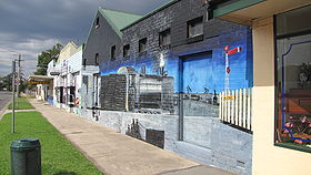 Peintures murales de Nar Nar Goon
 Australie

