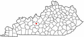
Leitchfield
Contenu soumis à la licence CC-BY-SA. Source : Article Leitchfield de Wikipédia en français (auteurs)
Regardez d'autres dictionnaires:
Leitchfield — Leitchfield, KY U.S. city in Kentucky Population (2000): 6139 Housing Units (2000): 2797 Land area (2000): 8.769014 sq. miles (22.711641 sq. km) Water area (2000): 0.030836 sq. miles (0.079866 sq. km) Total area (2000): 8.799850 sq. miles… … StarDict's U.S. Gazetteer Places
Leitchfield, KY — U.S. city in Kentucky Population (2000): 6139 Housing Units (2000): 2797 Land area (2000): 8.769014 sq. miles (22.711641 sq. km) Water area (2000): 0.030836 sq. miles (0.079866 sq. km) Total area (2000): 8.799850 sq. miles (22.791507 sq. km) FIPS … StarDict's U.S. Gazetteer Places
Leitchfield — Original name in latin Leitchfield Name in other language State code US Continent/City America/Chicago longitude 37.48005 latitude 86.29386 altitude 229 Population 6699 Date 2011 05 14 … Cities with a population over 1000 database
Leitchfield — Sp Ličfildas Ap Leitchfield L JAV Greisono apyg. c. (Kentukis) … Pasaulio vietovardžiai. Internetinė duomenų bazė
Leitchfield (Kentucky) — Leitchfield Ciudad de los Estados Unidos … Wikipedia Español
Leitchfield, Kentucky — Infobox Settlement official name = Leitchfield, Kentucky settlement type = City nickname = motto = imagesize = image caption = image mapsize = 250px map caption = Location of Leitchfield, Kentucky mapsize1 = map caption1 = subdivision type =… … Wikipedia
42754 — Leitchfield, Ky (Miscellaneous » ZIP Codes) … Abbreviations dictionary
42755 — Leitchfield, Ky (Miscellaneous » ZIP Codes) … Abbreviations dictionary
National Register of Historic Places listings in Grayson County, Kentucky — Location of Grayson County in Kentucky This is a list of the National Register of Historic Places listings in Grayson County, Kentucky. It is intended to be a complete list of the properties and districts on the National Register of Historic… … Wikipedia
List of Registered Historic Places in Kentucky (Fayette County to Hopkins County) — NOTOC =Fulton County= * Fulton ** Ben F., Jr. Carr House ** Carr Historic District ** Confederate Memorial in Fulton ** Fulton Downtown Historic District ** Jesse Whitesell House * Hickman ** Adams Site (15 Fu 4) ** Amburg Mounds Site (15FU15) ** … Wikipedia

 États-Unis
 Kentucky