- Herborn (bei Idar-Oberstein)
-
Herborn 

Administration Toponyme officiel Herborn Pays  Allemagne
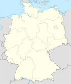
Land  Rhénanie-Palatinat
Arrondissement
(Landkreis)Arrondissement de Birkenfeld Code communal
(Gemeindeschlüssel)07 1 34 038 Code postal 55758 Indicatif téléphonique 06781 Immatriculation BIR Site web http://www.herborn-hunsrueck.de/ Politique Bourgmestre
(Ortsbürgermeister)Peter Remuta Partis au pouvoir Géographie Coordonnées Altitude (NN) 455 m Superficie 2.46 km2 Démographie Population 486 hab. (31/12/2009) Densité 198 hab./km2 modifier 
Herborn est une municipalité allemande située dans le land de Rhénanie-Palatinat et l'Arrondissement de Birkenfeld.
Catégorie :- Commune de Rhénanie-Palatinat


Wikimedia Foundation. 2010.