Umingmaktok
- Umingmaktok
-
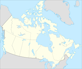
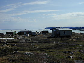
Umingmaktok (« il ou elle a attrappé un bœuf musqué ») est située dans la région de Kitikmeot dans le territoire canadien du Nunavut. La communauté était connue auparavant sous le nom de Bay Chimo et les Inuits réfèrent à la communauté en parlant de Umingmaktuuq (« comme un bœuf musqué »).
Le recensement de 2006 de Statistiques Canada n'y dénombre aucun habitant[1].
Références
Annexe
Article connexe
Wikimedia Foundation.
2010.
Contenu soumis à la licence CC-BY-SA. Source : Article Umingmaktok de Wikipédia en français (auteurs)
Regardez d'autres dictionnaires:
Umingmaktok — Umingmaktuuq Settlement Umingmaktuuq looking towards the Co op store … Wikipedia
Umingmaktok, Nunavut — The community of Umingmaktok ( he or she caught a Muskox ) is located in Bathurst Inlet in the Kitikmeot Region of Canada s Nunavut Territory. The community was previously known as Bay Chimo and the Inuit refer to the community as Umingmaktuuq (… … Wikipedia
Bathurst Inlet, Nunavut — NOTOC Bathhurst Inlet, (Inuinnaqtun: Qingaun or Qingaut , Inuktitut: ᑭᖓᐅᓐ), is a small Inuit community located in Bathurst Inlet in the Kitikmeot Region of Canada s Nunavut Territory. As of the 2006 census the population was 0 as opposed to 5… … Wikipedia
Kitikmeot — 68°55′N 100°45′W / 68.917, 100.75 … Wikipédia en Français
List of communities in Nunavut — This is a list of communities in Nunavut Territory, Canada. Note that many of these communities have alternate names or spellings in Inuktitut or Inuinnaqtun, while others are primarily known by their Inuktitut or Inuinnaqtun names. As of the… … Wikipedia
Commissioners of Nunavut — Commissioner of Nunavut Flag of the Office: Incumbent: Edna Elias First commissioner: Helen Maksagak Formation: Apr … Wikipedia
Cambridge Bay, Nunavut — Infobox Settlement official name = Pagename other name = Iqaluktuuttiaq native name = nickname = settlement type = Hamlet motto = imagesize = 295px image caption = Aerial view of Cambridge Bay looking north flag size = image seal size = image… … Wikipedia
List of Aboriginal communities in Canada — The following is a list of Aboriginal communities in Canada. While communities for all Aboriginal peoples in Canada (the First Nations, Inuit, and Métis) are included, the list is largely made up of Indian reserves, which are sometimes… … Wikipedia
Nunavut Arctic College — Coordinates: 63°43′39.41″N 68°26′40.42″W / 63.7276139°N 68.4445611°W / 63.7276139; 68.4445611 … Wikipedia
Highways in Nunavut — Currently,[when?] an estimated total of 850 km (530 mi) of roads and highways are spread across Nunavut. Over the next decade the amount of roads in the territory is expected to increase rapidly as more communities are linked together,… … Wikipedia
 Canada
 Nunavut