Balliang
Contenu soumis à la licence CC-BY-SA. Source : Article Balliang de Wikipédia en français (auteurs)
Regardez d'autres dictionnaires:
Shire of Moorabool — Victoria Location in Victoria Population … Wikipedia
Anakie, Victoria — Infobox Australian Place | type = town name = Anakie state = vic caption = The general store at Anakie lga = City of Greater Geelong postcode = 3221 est = pop = 674 (2006)Census 2006 AUS | id = SSC25021 | name = Anakie (State Suburb) | accessdate … Wikipedia
List of localities in Victoria (Australia) — Map of Local Government Areas in Victoria This is a list of locality names and populated place names in the state of Victoria, Australia, outside the Melbourne metropolitan area. It is organised by region from the south west of the state to the… … Wikipedia
Lara, Victoria — Lara Geelong, Victoria … Wikipedia
Wyndham Vale, Victoria — Infobox Australian Place | type = suburb name = Wyndham Vale city = Melbourne state = vic caption = lga = City of Wyndham postcode = 3024 pop = 10,355 (2006)Census 2006 AUS | id = SSC21743 | name = Wyndham Vale (State Suburb) | accessdate = 2007… … Wikipedia
Electoral district of Melton — The Electoral district of Melton is an electoral district of the Victorian Legislative Assembly.It contains the towns of Bacchus Marsh, Balliang, Balliang East, Bellevue Hill, Blackwood, Greendale, Kurunjang, Melton, Melton South, Mount Cottrell … Wikipedia
Myrniong, Victoria — Myrniong Victoria Myrniong seen from the west. The Western Freeway can be seen to the right … Wikipedia
Mount Egerton, Victoria — Mount Egerton Victoria Mount Egerton General Store … Wikipedia
Darley, Victoria — Darley Bacchus Marsh, Victoria … Wikipedia
Dunnstown, Victoria — Dunnstown Victoria The Shamrock Hotel … Wikipedia
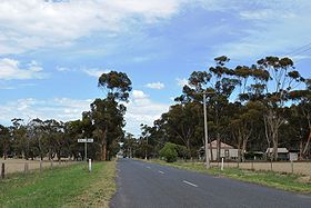 La grand'rue de Balliang
 Australie

