Firth of Lorn
- Firth of Lorn
-

Pour les articles homonymes, voir
Firth.
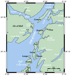
Le Firth of Lorn, parfois appelé de manière non officielle Firth of Lorne, en gaélique écossais An Linne Latharnach, est un firth situé dans l'Ouest de l'Écosse, au Royaume-Uni. Il constitue une avancée de l'océan Atlantique dans les Hébrides intérieures, séparé par l'île de Mull à l'ouest et le reste de l'Écosse à l'est, notamment les îles Slate. Il communique au nord avec le détroit de Mull, le Lynn of Lorne ainsi que le Loch Linnhe et au sud avec l'océan Atlantique.
Wikimedia Foundation.
2010.
Contenu soumis à la licence CC-BY-SA. Source : Article Firth of Lorn de Wikipédia en français (auteurs)
Regardez d'autres dictionnaires:
Firth of Lorn — [ fəːθ əv lɔːn], zwischen den Inseln Mull und Jura in die Westküste Schottlands eingreifender Meeresarm … Universal-Lexikon
Firth of Lorn — The Firth of Lorn (or Lorne , unofficially) (Scottish Gaelic: An Linne Latharnach) is a body of water on Scotland s west coast, in Argyll and Bute. It lies between the Isle of Mull to the northwest and the Isles of Kerrera, Seil and Luing (the… … Wikipedia
Firth of Lorn — Sp Lòrno fjòrdas Ap Firth of Lorn L Hebridų j. įl., D. Britanija (Škotija) … Pasaulio vietovardžiai. Internetinė duomenų bazė
Firth of Lorn — noun A strait or firth between the Isle of Mull and the Slate Islands … Wiktionary
Lunga, Firth of Lorn — Infobox Scottish island latitude=56.22 longitude= 5.70 GridReference=NM706086 celtic name=Lunga norse name=Langr oy meaning of name= Old Norse for isle of the longships area=254 ha (628 acres) area rank=96 highest elevation= Bidean na h Iolaire… … Wikipedia
Firth — is the Lowland Scots word used to denote various coastal waters in Scotland. It is usually a large sea bay, which may be part of an estuary, or just an inlet, or even a strait. It is cognate to fjord (both from Proto Germanic *ferþuz) which has a … Wikipedia
Firth — Cette page d’homonymie répertorie les différents sujets et articles partageant un même nom. Firth peut désigner : Raymond Firth, un anthropologue néo zélandais ; Colin Firth, un acteur britannique ; Jason Firth, un joueur de hockey … Wikipédia en Français
Lorn, Firth of — or Firth of Lorne geographical name strait W Scotland between E Mull Island & mainland … New Collegiate Dictionary
Firth of Lorne — geographical name see Lorn, Firth of … New Collegiate Dictionary
Lorne,Firth of — Lorne also Lorn (lôrn), Firth of An inlet of the Atlantic Ocean on the western coast of Scotland between Mull Island and the mainland. * * * … Universalium
 Royaume-Uni


 Portail de l’Écosse
 Portail du monde maritime