Adisham
Contenu soumis à la licence CC-BY-SA. Source : Article Adisham de Wikipédia en français (auteurs)
Regardez d'autres dictionnaires:
Adisham — infobox UK place static static image caption=Adisham Church of England Primary School country = England official name= Adisham latitude= 51.2415longitude= 1.1902 population = 620 [ [http://www.neighbourhood.statistics.gov.uk/dissemination/LeadTabl… … Wikipedia
Adisham railway station — Infobox UK station name = Adisham code = ADM manager = Southeastern. locale = Adisham borough = Canterbury lowusage0405 = 53,898 lowusage0506 = 53,857 lowusage0607 = 58,776 platforms = 2 start = 22 July 1861 latitude = 51.2409 longitude =… … Wikipedia
Bandarawela — Infobox Settlement official name = Bandarawela map caption = Map of Badulla district showing the situation of Bandarawela. pushpin subdivision type = District subdivision name = Badulla District leader title = Mayor leader name = Nalin Priyantha… … Wikipedia
City of Canterbury — For the settlement within the City of Canterbury, see Canterbury. For the local government area in Australia, see City of Canterbury (New South Wales). City of Canterbury Non metropolitan district, Borough, City … Wikipedia
Kent coalfield — The Kent coalfield was located in the eastern part of the English county of Kent.Coal was discovered in the area in 1890 while borings for an early Channel Tunnel project were taking place and the resultant Shakespeare colliery lasted until 1915 … Wikipedia
John Reynolds (1703-1779) — John Reynolds of Dane Court, Adisham, Kent (1703 1779) was an early agricultural pioneer. The son of Thomas Reynolds, a Kent Yeoman, John Reynolds enlarged the family farm and developed agricultural methods which came to the attention of the… … Wikipedia
East Kent Light Railway — The East Kent Light Railway was part of the Colonel Stephens group of cheaply built rural light railways in England. Holman Fred Stephens was engineer from its inception, subsequently becoming director and manager. The line ran from Shepherdswell … Wikipedia
List of schools in Kent — List of primary schools, middle schools, secondary schools, special schools, further education colleges and universities in the ceremonial county of Kent, England. [cite web | title = UK Schools Colleges Database | publisher = Schools Web… … Wikipedia
Archie McKellar — Infobox Military Person name=Archibald Ashmore McKellar lived=10 April 1912 2 November 1940 placeofbirth=Paisley, Renfrewshire, Scotland placeofdeath=Adisham, Kent, England caption= nickname= allegiance=flagicon|United Kingdom United Kingdom… … Wikipedia
Canterbury — For the larger local government district, see City of Canterbury. For other uses, see Canterbury (disambiguation). Coordinates: 51°16′30″N 1°05′13″E / 51.275°N 1.0 … Wikipedia
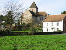
 L'église Holy Innocents à Adisham
 Angleterre
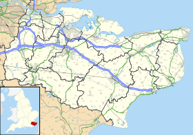
 Adisham
