Selianitika
Contenu soumis à la licence CC-BY-SA. Source : Article Selianitika de Wikipédia en français (auteurs)
Regardez d'autres dictionnaires:
Selianitika — Σελιανίτικα … Deutsch Wikipedia
Selianitika — Infobox Greek Dimos name = Selianitika name local = Σελιανίτικα periph = Western Greece prefec = Achaia municipality = Sympoliteia population = 1147 population as of = 2001 area = 2.8 elevation = lat deg = 38 lat min = 16 lon deg = 22 lon min = 1 … Wikipedia
Selianitika — Original name in latin Seliantika Name in other language Selianitika, Seliantika State code GR Continent/City Europe/Athens longitude 38.28333 latitude 22.03333 altitude 63 Population 1210 Date 2012 01 18 … Cities with a population over 1000 database
Longos, Achaea — Infobox Greek Dimos name = Longos name local = Λόγγος periph = Western Greece prefec = Achaia municipality = Sympoliteia population = 761 population as of = 2001 area = elevation = lat deg = 38 lat min = 17 lon deg = 22 lon min = 1 postal code =… … Wikipedia
Rodia, Achaea — Rodia (Greek: Ροδιά), also with the a accented is a Greek town located nearly 10 to 15 km southeast from Aigio, west of Corinth and north northwest of Kalavryta. Rododafni had a population of 431 in 2001. Selianitika is in the municipality of… … Wikipedia
Greek National Road 8A — Route information History: Constructed 1962–1973 Major junctions East … Wikipedia
Rododafni — (Greek: Ροδοδάφνη), older name: Mourla is a Greek village located 30 km southeast by the old road and 35 km east by the new road from Patras, about 10 km west of Aigio, west of Corinth and north northwest of Kalavryta. Rododafni had a population… … Wikipedia
GR-A8 — Autobahn 8 (Aftokinitodromos 8) Länge: 215 km … Deutsch Wikipedia
GR-EO8a — Nationalstraße 8a (Ethiniki Odos 8a) Länge: ca. 215 km … Deutsch Wikipedia
Gulf of Corinth — The Peloponnesos, seen from space The Gulf of Corinth or the Corinthian Gulf (Κορινθιακός Kόλπος, Korinthiakόs Kόlpos, in Greek) is a deep inlet of the Ionian Sea separating the Peloponnese from western mainland Greece. It is bounded in the east… … Wikipedia
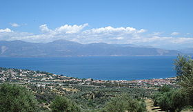 Photo panoramique de Selianitika et Longos
 Grèce
Grèce
 Selianitika
