Panjshir

Panjshir

Pandjchir

پنج شیر
(Pandjchir)
Carte de l'Afghanistan mettant en évidence le Pandjchir.
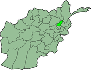
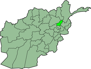
Administration
Pays Afghanistan
Type Province
Capitale Rokha
Géographie
Superficie 3 610 km²
Démographie
Population 428 620 hab. (?)
Densité 91 hab./km²

Le Panshir ou Pandjchir (en persan, پنجشیر, « Cinq Lions », پنج شیر, en référence à cinq walis qui habitèrent la vallée) est une province de l'est de l'Afghanistan. Sa capitale est Rokha (ou Rokhah).

Sommaire

Un verrou qui n'a jamais été soumis aux occupations extérieures

Les habitants du Panjchir sont d'ethnie tadjike, qui represente 40% de la population de l'Afghanistan. Ses habitants sont connus par leur physique typiquement européen, leur sens de la liberté, et leur courage.

La vallée du Panjshir, de même que le tunnel de Salang, est une voie d'accès vers le nord de l'Afghanistan. Cette région a été le théâtre de nombreuses offensives soviétiques puis des talibans, mais a toujours été défendue avec succès par Ahmed Chah Massoud.

Districts

La province est subdivisée en 7 districts [1]:

  • Bazarak
  • Rukha
  • Uanaba
  • Dhara
  • Hesa-e-Awal
  • Chotol
  • Paryan

Économie et ressources naturelles

Un gisement d'émeraude d'un grand potentiel et décrit dans les écrits de Pline l'Ancien, est localisé dans cette région.
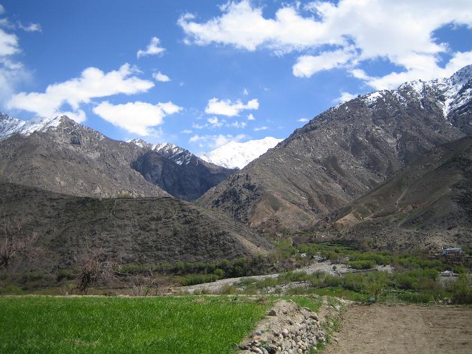
Galerie

Notes et références de l'article

Voir aussi

Liens et documents externes


Provinces d'Afghanistan Drapeau de l'Afghanistan
Badakhchân • Bâdghîs • Baghlân • Balkh • Bâmiyân • Deykandi • Djôzdjân • Farâh • Fâryâb • Ghazni • Ghôr • Helmand • Hérât • Kaboul • Kandahâr • Kâpîssâ • Khôst • Kounar • Kondôz • Laghmân • Lôgar • Nangarhâr • Nimrôz • Nourestân • Orozgân • Paktîkâ • Paktiyâ • Pandjchir • Parwân • Samangân • Sar-é Pol • Takhâr • Wardak • Zâbol
Ce document provient de « Pandjchir ».

Wikimedia Foundation. 2010.

Contenu soumis à la licence CC-BY-SA. Source : Article Panjshir de Wikipédia en français (auteurs)

Игры ⚽ Поможем написать курсовую

Regardez d'autres dictionnaires:

  • Panjshir — may refer to:* Panjshir Valley * Panjshir Province * Panjshir River …   Wikipedia

  • Panjshir —   [ dʒʃir], Panjsher, linker Nebenfluss des Kabul in Nordostafghanistan, entspringt im Hindukusch; durch das Tal des oberen Panjshir verläuft der Weg zum Anjomanpass …   Universal-Lexikon

  • Panjshir — ‏پنجشیر‎ Panjshir Basisdaten Staat …   Deutsch Wikipedia

  • Panjshir — Admin ASC 1 Code Orig. name Panjshir Country and Admin Code AF.42 AF …   World countries Adminstrative division ASC I-II

  • Panjshir (Fluss) — Panjshir Panjshir TalVorlage:Infobox Fluss/KARTE fehlt DatenVorlage:I …   Deutsch Wikipedia

  • Panjshir offensives — Part of the Soviet war in Afghanistan Date 1980 1985 Location Panjshir Valley, Afghanistan Result …   Wikipedia

  • Panjshir Valley — The Panjshir Valley, also spelled Panjsher Valley (PerB|دره پنجشير Dara ye Panjšēr ; literally Valley of the Five Lions ) is a valley in north central Afghanistan, 150km north of Kabul, near the Hindu Kush mountain range.cite… …   Wikipedia

  • Panjshir Province — Geobox|Province country = Afghanistan country name = Panjshir native name = پنج شیر map caption = Map of Afghanistan with Panjshir highlighted capital = Bazarak capital lat d = 35.4 capital long d = 70.0 population as of = population = 328,620… …   Wikipedia

  • Panjshir River — The Panjshir River flows through the Panjshir Valley in northeastern Afghanistan, 150km north of Kabul. It flows southward through the Hindu Kush and adjoins the Kabul River near Sarobi. At this junction, a dam was built in the 1950s to supply… …   Wikipedia

  • Provincia de Panjshīr — Saltar a navegación, búsqueda Mapa de la provincia de Panjshīr en Afganistán. Panjshīr (literalmente Los cinco leones del persa: پنج شیر), es una de las 34 provincias de Afganistán. Establecida el 13 de abril de 2004. Tiene una población… …   Wikipedia Español

Share the article and excerpts

Direct link
Do a right-click on the link above
and select “Copy Link”